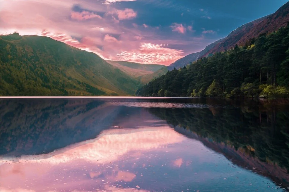
The Ultimate List of Best Hikes in the World According to These Adventurous Travel Bloggers

If you’re anything like me, you’ve got crazy, strong wanderlust pretty much… all the time! But for me, I like all my world travel to include some aspect of adventure to them which is why I’m super excited to publish this ultimate list of best hikes in the world! I reached out to some of the top adventure & travel bloggers for their favorite hikes from around the globe, and we’ve compiled that list into this epic binge-worthy post.
And of course I’ve sprinkled in a few of the hikes I personally consider the worlds best hikes into this post as well.
So without further ado and fluff, here you go:
The Ultimate List of Best Hikes in the World
There’s a lot of great info in this post, but I wanted to make sure it was easy for you to browse through, so we’ve organized the hikes according to region of the world for easier wanderlust browsing. You’ll also find a ton of useful links in this post for planning your own trip to do each and every one of these hikes if you so chose to.
How we’ve organized this list of world’s best hikes:
Best Hikes in North America
Best Hikes in South America
Best Hikes in Asia
Best Hikes in Africa
Best Hikes in Europe
Best Hikes in Oceana
GRAB MY [FREE] OUTDOOR BACKPACKER STARTER KIT:
I created the Ultimate Outdoor Backpacker Starter Kit for you (and it's FREE)! This starter kit is filled with 14 pages of my best hiking and backpacking tips to help you learn what it takes to become a safe, confident, and self-sufficient outdoor backpacker!
The Best Hikes in North America
Half Dome Hike - California
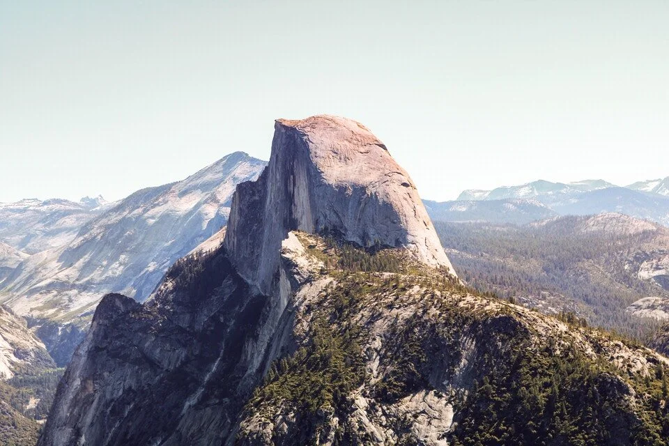
Half Dome Hiking Details:
Location: Yosemite National Park, California, USA
Length: ~14 miles
Elevation Gain: 4,200 feet
Difficulty: Difficult
Permits needed? Yes you need a Half Dome hiking permit
Half Dome is probably one of Yosemite’s most popular hikes and is arguably one of the best hikes in the US. The Dome rises to 8,842 feet high and the trail is around 14 miles with 4,200 feet of total elevation gain. Many choose to do this trail in one day (which takes most people 10-14 hours), but you can also opt to backpack this trail over 2-3 days.
There are two main trails that converge at the top of Nevada Falls that you can take on your way to the summit. Those two trails come together and continue on the main trail up toward Half Dome. You can take the Mist Trail, which is steeper but shorter in length and more scenic, or you can take the John Muir Trail which is 1.5 miles longer each way, but less steep. When I went on this hike we took Mist Trail on our way up and John Muir Trail on our way down because it was easier on our knees.

If you want to break up your mileage and opt to backpack the trail, consider staying at Little Yosemite Valley, which is only a mile past the top of Nevada Falls. This is a backpackers only campground and a great way to break up the hike.
If you want to hike to the top of Half Dome, you are required to have Half Dome hike permits. Without a permit, you can only hike to the base of the sub-dome. If you want to camp along the hike, Yosemite Wilderness permits are required for that too. A maximum of 300 total hikers are allowed per day (225 hikers and 75 backpackers)
Bring some gloves with you for the cables on this hike! I'm always surprised by the number of people who don't, but it will help you feel much more safe going up and down the cables. Also, wear shoes that have good traction, this will just help you feel even more confident on the granite rock up to Half Dome summit.
Read my full Half Dome Trail Guide, for even MORE details about planning and preparing for this iconic hike.
Note: If you can’t get permits to hike Half Dome, it’s still worth visiting Yosemite National Park. Take a classic road trip through California and spend time here in this epic National Park, and opt for a hike that doesn’t require a permit like the Clouds Rest hike.
Want to Read More Resources about the Half Dome and Sierra Nevada Area?
The complete Half Dome Hike Overview & Planning Guide
Check out our 21 Absolute Best Hikes in Yosemite National Park to Put on Your Hiking Bucket List
Learn more about the Half Dome Permit Lottery process
Learn more about Important Permit & Reservation Deadlines for Popular California Hiking Trails & Campsites
Havasu Falls Hike - Arizona
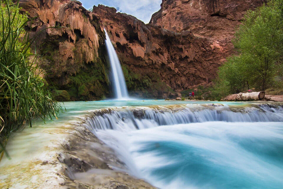
Havasu Falls Hike Hiking Details:
Location: Arizona, USA
Length: ~25 Miles Round Trip
Elevation Gain: 2,500 feet
Difficulty: Moderate
I’m not going to lie to you, the Havasu Falls hike is one of the most beautiful backpacking trails I’ve ever gone on and definitely one of the best treks in the world. Definitely in the top five, if not in the top three. By this point, with social media being what it is today, most of you have probably seen photos from other outdoor enthusiasts and backpackers hiking into Havasupai Falls, and it’s probably something you immediately thought either, “That looks fake,” or “I HAVE to do this!”. Don’t worry, you’re in good company. I thought both of those exact things.
The photos and colors are real my friend. The beautiful bright blue waterfalls that you see while hiking into Havasupai Falls look like something out of a dream or from a different dimension.

The hike is roughly 25 miles long round trip if you hike all the way down to Beaver Falls which is the final waterfall of the hike, and you should plan to spend 3 days doing this hike. Spend a day hiking down, a day to explore all the waterfalls, and a day to hike out.
Do your best to try and hike in the mornings, when it is cooler outside, and enjoy the water and waterfalls during the heat of the day. It’s hard to pick just one thing that makes this hike so special. All 5 waterfalls are breathtaking, and the hiking is a blast! Be sure to put this iconic US hike on your list, but plan ahead because permits are required to hike this trail!
I have an EPIC blog post, with everything you need to know about this hike:
The ULTIMATE Guide to the Havasu Falls Hike - Backpacking Trail Details, Camping, Permits, Weather, Photography, and More
Want to Read More Resources about the Havasu Falls Hike & the Arizona Area?
The Complete Havasu Falls Hiking Packing List
Arizona: Best Hikes in Sedona Arizona
Arizona: Hiking Humphreys Peak (Tallest Peak in Arizona)
Mount Whitney Hike - California
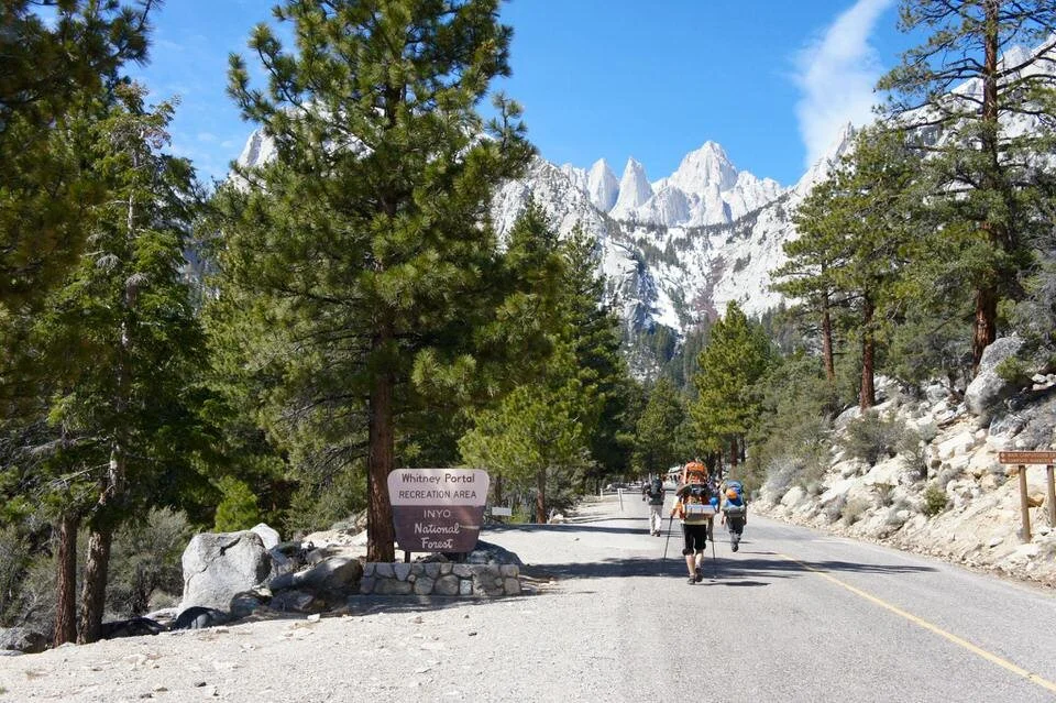
Mount Whitney Hiking Details:
Location: California, USA
Length: 22 miles
Elevation Gain: 6,100 feet of gain
Difficulty: Difficult
Another really popular hike in California is the Mount Whitney Trail hike, and it is very competitive to get a Mount Whitney hike permit. Mount Whitney is the tallest peak in the contiguous United States and thus makes it to the top of almost everyones list.
The Mount Whitney trail is a very difficult hike as it is a California 14,000 foot peak. It is 22 miles in length and about 6,100 feet of total elevation gain. So unless you are in great physical shape, I'd opt to backpack this trail for a more enjoyable experience. Also, backpacking will help you acclimate to the higher altitude better.
You can opt to day hike this or backpack this trail, but both require Mount Whitney permits. If you choose to backpack this trail you can camp at Trail Camp, Outpost Camp, Consultation Lake, or Lone Pine Lake.
Most people do this hike in the summer. Lottery applications can be made for May 1 through November 1, but keep in mind that depending on the snow year, the trail may not be clear of snow until July. It is probably best to aim to do this hike July through early October for best chances of a clear trail. Personally, I'd opt for September, because that will be the best temperatures.
Want to Read More Resources about the Mount Whitney Trail and Sierra Nevada Area?
Backpack from Onion Valley to Whitney Portal and snag a summit of Mount Whitney along the way
Read More Here about a Winter Ascent of Mount Whitney Via it’s Mountaineers Route
7 Tips for hiking your first 14,000 foot mountain
Learn more about Important Permit & Reservation Deadlines for Popular California Hiking Trails & Campsites
Delicate Arch – Moab, UT

Delicate Arch Hiking Details:
Location: Moab, Utah, USA
Length: 3.1 Miles Roundtrip
Elevation Gain: ~613 ft elevation gain
Difficulty: Moderate
One of the most iconic hikes in the USA is the world-famous Delicate Arch Hike in Utah. This trail is 3.1 miles, with an elevation gain of 613 feet, and is rated as moderate. The trail is extremely popular due to the view of its namesake arch.
The beginning of the hike begins near a cute cabin called the Wolfe Ranch Cabin. The cabin was built in 1906 by a man named John Wesley Wolfe and has since been bought by the United States government. You cannot enter the cabin, but it is a nice view of US history.
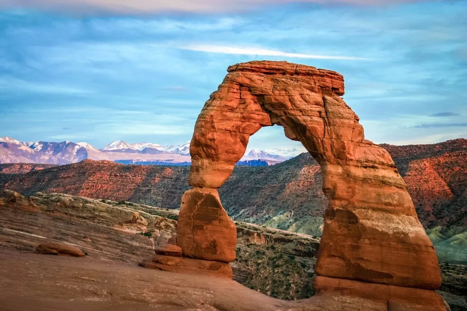
After the cabin, you are on a casual stroll, but eventually, there is a vast elevation gain. Finally, the trail levels out, and you are left with beautiful views of different rock formations. To get to Delicate Arch itself, you need to follow a massive rock wall. It will take you to the glorious views of Delicate Arch. You can get up close to the Arch and even stand underneath it.
Since Delicate Arch is so popular, getting a good picture with the Arch is difficult. Luckily, there is a secret to obtain the perfect picture. If you do the hike during sunrise in the wintertime, there are a lot fewer crowds. Our group was actually the only one at the Arch during this time, and the picture was worth getting up extremely early for.
Contributed by Michelle Stelly, The Wandering Queen - Read More About the Delicate Arch Hike Here
Want to Read More Resources about hiking in Utah?
Utah Desert Hike: Kanarra Falls Hike
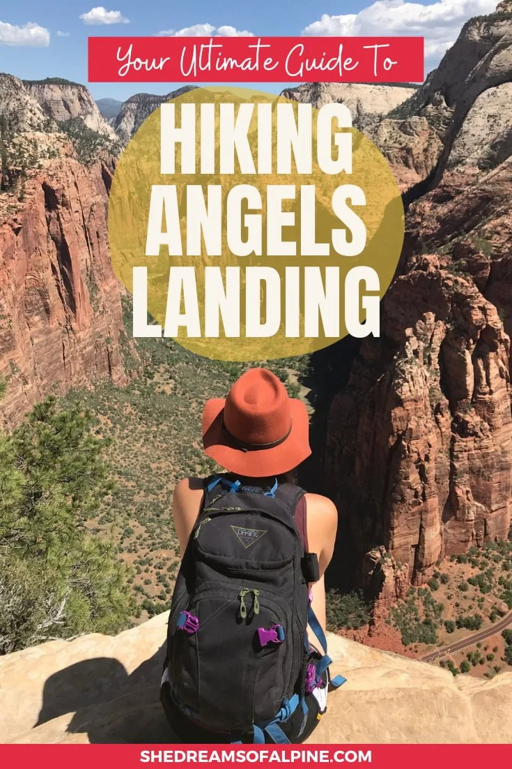
Angels Landing - Utah

Angels Landing Hike Hiking Details:
Location: Zion National Park Utah, USA
Length: ~5 miles roundtrip
Elevation Gain: 1,800 feet
Difficulty: Difficult
The Angels Landing hike in Zion National Park is one of the MOST ICONIC hikes in Zion, and one of the best hiking trails in the world in my opinion . It’s a true classic in every way. The views are absolutely unmatched and the trail will challenge you both physically and mentally the whole way up.
The Angels Landing trail is 5 miles total round trip with about 1800 feet of total elevation gain to get to the top, which translates to a pretty consistent, challenging uphill hike the entire way. There is no permit required to hike the trail at this time, but it is definitely a very crowded trail.
It’s best to do this trail very early in the day to not only avoid the crowds, but also the heat, or better yet, go during the off-season. This hike is most well-known for its narrow trail toward the top of the hike, where sometimes the path is only a few feet wide. There are cables all along the way, but those with a fear of heights might find the 1,000 foot drop offs to be extremely terrifying. However, if you take your time, maintain 3 points of contact on your way up, and breathe, you’ll find yourself at the top of Angels Landing with some of the best views of Zion National Park, plus bragging rights to boot.
Want to Read More Resources about hiking Angels Landing?
The Ultimate Guide to the Angels Landing Hike in Zion National Park
Plain of Six Glaciers – Banff, Alberta
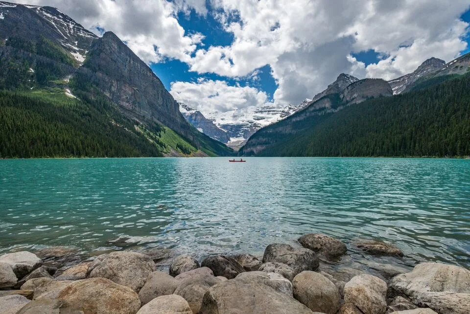
Plain of Six Glaciers Hiking Details:
Location: Banff, Canada
Length: ~ 8 miles round trip
Elevation Gain: ~1,925 ft elevation gain
Time to complete: 5-6 hours
Difficulty: Moderate
Lake Louise is home to some of the most beautiful hikes in the world, and one of the best ways to experience the lake is by hiking to the glacier that feeds it. The Plain of Six Glaciers hike is spectacularly beautiful, rewarding, challenging, yet doable for most people.
The 8-mile round trip hike starts from Lake Louise’s lakeshore. The first 2.5 miles meander through the woods beside the glistening teal-colored water before veering off and heading uphill for the second 2 miles. The trail makes its way past a cascading waterfall, through pine forests, before eventually reaching the “plain of six glaciers,” a moon-like landscape that was carved by, you guessed it, six different glaciers. A handful of them can be seen. The hike is a steady climb at that point, but the scenery makes you forget how hard you will probably be breathing.
Most hikes only have one reward at the top, but this one has two. First is the queen of the six glaciers, Victoria Glacier. The very end of the trail follows a ridge to the toe of the glacier itself. Victoria Glacier feeds Lake Louise, and once you’re this close to it, you can actually hear it “roar” every now and then! The second reward is the tea house, which serves tea, coffee, and delicious soups, sandwiches, and chocolate cakes throughout the summer. (Note: it’s cash only, so make sure to bring some with you!)
Budget about 5-6 hours for this hike. The total elevation gain is about 1,925 feet, and you can definitely feel the altitude difference at the end. But it’s worth it!
Contributed by Maggie McKneely, Pink Caddy Travelogue – Read More about the Plain of Six Glaciers Hike Here
Want to Read More Resources about hiking in Canada?
Check out these 5 Breathtaking Icefields Parkway Hikes
Tamolitch Blue Pool – Oregon
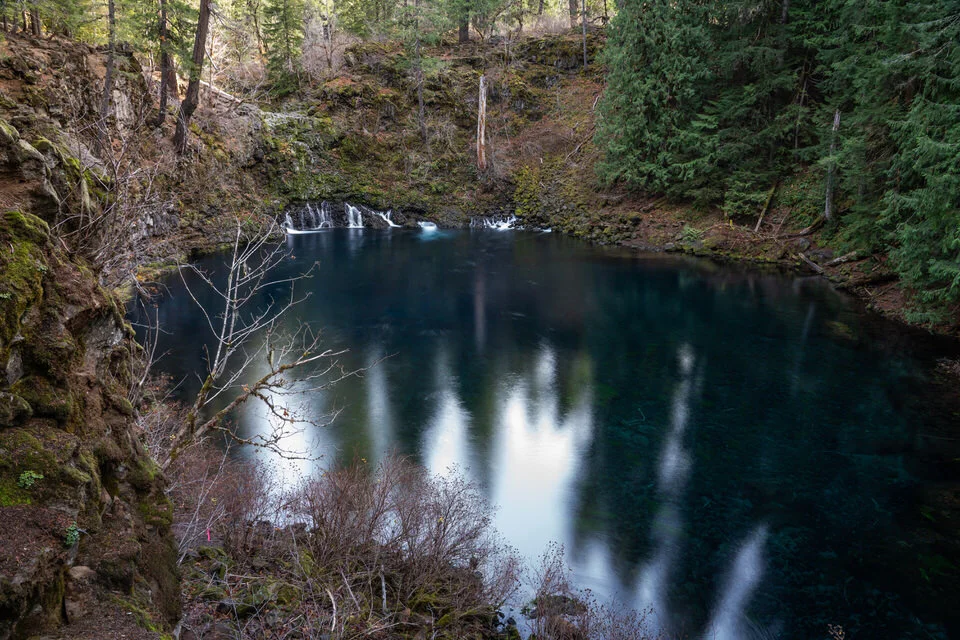
Tamolitch Blue Pool Hiking Details:
Location: Oregon, USA
Length: ~ 4 miles round trip
Elevation Gain - Minimal
Time to complete: 2 hours
Difficulty: Easy
Tamolitch Blue Pool literally looks like a dream. The water is a seemingly impossible deep blue, and it’s in Oregon which means it’s pretty much guaranteed to be beautiful. I was expecting to get there and be disappointed because I figured all the photos I saw were photoshopped, but it really is THAT blue! And no, it’s not Kool-Aid that creates this beautiful color, but rather, the McKenzie River resurfacing after flowing underground through lava fields!
The hike itself is 2 miles each way with only 200 feet of elevation gain. Expect it to take around 2 hours total (unless you stop for an hour plus to take photos, which, let’s be real, you probably will). There is no cell service at the pool, though, so you’ll have to upload your Instagram photos later. It’s open year round, but fires can sometimes close it during the summer/fall months, so be sure to check its status online here. You can even swim in the pool if you’re up for it, but the water temperature is about 37F year round so it’s pretty cold. My friend took the plunge, but I’m pretty much convinced she’s a robot.
To get to the trailhead, take the McKenzie Highway 126 east about 10 miles and turn at the Trailbridge Campground sign. You’ll soon cross a bridge and then turn right onto a gravel road, which will take you shortly to the signs for trail crossing - park there. The hike is located right on the McKenzie River Trail, and you can just begin at the Tamolitch Trailhead.
Pro Tip: This hike has been seriously gaining in popularity lately, so if you want to avoid the crowds go on a weekday/early in the morning/evening. And I’m sure you know this already (being responsible hikers and all) but PLEASE do not leave anything behind (except maybe your dignity). The area has seen a lot of trash and destruction as of late due to its aforementioned rise in foot traffic, so you may even want to bring a plastic bag and pick up any litter you find ;)
Contributed by Kelsey Frey, Sights Better Seen
Rim to Rim Hike - Arizona

Rim-to-Rim Hiking Details:
Location: Grand Canyon National Park, Utah, USA
Length: ~23.5 miles
Elevation Gain: ~4,000 if going from North Rim to South Rim
Difficulty: Difficult if attempted in 1 day
The state of Arizona is filled with some of the most classic hiking and backpacking trails in the entire United States. You could spend a few weeks exploring and road tripping around Arizona to hike some of its best trails, and still not see all that it has to offer. The Rim to Rim Hike in the Grand Canyon though is by far one of it’s most epic, best hiking trails of all.
Starting in the Grand Canyon you could start with an epic challenge of hiking the Rim to Rim hike in one day, a 24 mile point-to-point hike that gives you the best tour of the Grand Canyon out of any other hikes in that area. It’s like hiking into a lost world, and one of the best hikes in Arizona. This is a very strenuous hike and should be only attempted if you are well prepared and trained for the trip
If you’d still like to hike the Rim-to-Rim Trail, but don’t want to do it in one day you can try to snag backpacking permits, but make sure to plan ahead accordingly because they go fast!
Vulcan Acatenango – Antigua, Guatemala

Vulcan Acatenango Hiking Details:
Location: Antigua, Guatemala
Length: ~5 miles
Elevation gain: ~4,900 feet
Difficulty: Difficult
Climbing fifteen hundred meters in eight kilometers is no joke. But to watch the world’s most active volcano erupt almost nonstop, it's well worth the sweat. Acatenango is located about an hour outside of Antigua, Guatemala. There are numerous tour companies in the city that will arrange all of your equipment and permits.
We decided to skip the prearranged tour and arrived at the base of the mountain with our own gear. We met a local guide who said we could use his company's campsite and up we went. The climb is strenuous even for the fit, although it is nothing but steep walking. The views are fantastic. And then as you near the summit of Acatenango, you begin to hear Vulcan Fuego. It spits magma hundreds of feet into the air every 10 - 20 minutes. As night falls, the liquid glows red and you'll find yourself staring for hours until sunrise.
Contributed by Chris Haag, The Places I Pee – Read more about Vulcan Acatenango here.
Grab My Essential Hiking Packing Checklist!
Best Hikes in South America
Laguna Torre – El Chaltén, Argentina

Laguna Torre Hiking Details:
Location: El Chalten, Argentina
Length: ~11 miles
Elevation Gain: 1,700 feet
Difficulty: Moderate
Patagonia features some iconic trekking and hiking experiences, and no trip to Argentinean Patagonia is complete without hiking to Laguna Torre.
The Laguna Torre trail begins right from the town of El Chaltén, the trekking capital of Argentina. This small and charming tourist town is in Los Glaciares National Park and surrounded by stunning scenery. Thanks to its fantastic location, there are no additional fees or permits required to hike to Laguna Torre.
This out and back trail is just over 11 miles round trip. It’s moderately difficult, with an elevation gain of approximately 1,700 feet. The first 1.5 miles is probably the most challenging.
At the start of the hike you’ll pass by Cascada Margarita, a beautiful waterfall that tumbles all the way down the mountainside into Rio Fitz Roy. Then, after about a mile and a half, you’ll reach a scenic lookout from which you can see several of the area’s famous peaks, including the very tip top of Cerro Fitz Roy. Continuing along, you’ll meander through open fields, forests, and a broad river plain.
While hiking, make sure to keep your eyes open for wildlife such as the condor, Magellanic Woodpecker, Patagonian fox and, if you’re lucky, puma.
After the final climb up and over the rocky moraine, you’ll see the most stunning view, and the highlight of the trail, the laguna, glaciar and cerro Torre. Unlike many other lakes in the region, this one is not a bright blue color. Instead you’ll find murky, grayish water with floating pieces of ice due to the glacier. Despite the water color, the scenery is breathtaking and unlike any other. Stick around long enough and you might hear the ice cracking and witness some calving.
For those interested in trekking further and longer, there are several connecting trails that will take you to other fantastic sites throughout the National Park. If you’re satisfied with a day hike, head back to cozy El Chaltén on the same trail after getting your fill of Laguna Torre.
Contributed by Brittany McNamara, B Out Exploring – Read more about South America here.
Want to Read More Resources about hiking in Patagonia?
Check out our article on 7 Breathtaking Patagonia Hiking and Backpacking Trips to Put on Your Trekking Bucket List!
Salkantay Trek – Machu Picchu, Cusco, Peru

Salkantay Trek Hiking Details:
Location: Machu Picchu, Cusco, Peru
Length: ~46 miles
Time to Complete: 3-5 days
Difficulty: Moderate
Visiting Machu Picchu in Peru is probably part of everyone’s bucket list. Sure, you can take the train and bus to get there, but you can also hike. So, if you like an adventure before rewarding yourself with one of the new world wonders, a trek might just be the perfect fit for you.
Many people try to score a place for the Inca Trail. However, this involves planning months ahead, which is impossible for some people (including me). The alternative is the Salkantay Trek. This hiking adventure brings you through diverse landscapes and offers incredible views of the Andes. You’ll get to see a beautiful turquoise laguna, snow-capped mountains, tropical rainforest, and waterfalls. One day you’ll be freezing with winter temperatures, and the other day, you’ll be sitting in a hot spring in a warm climate. It is surely one of the most iconic hikes in the world.
You can do the Salkantay Trek within 3, 4, or 5 days. We opted for a 5-day hiking trip (46 mi / 75 km) because the daily distances are more beginner-friendly. The biggest challenge is the second day. You’ll hike 2,068 ft (630 m) uphill to the highest point of the whole trek (Salkantay Pass at 15,190 ft / 4630 m). After this, it’s pretty relaxing, actually.
Being so high in the mountains will affect your breathing and endurance. The air is thinner, so even the smallest elevations are hard to manage. You should take a few days in Cusco before the trip so that you can acclimatize. This may prevent altitude sickness on the trek.
It is possible to do the Salkantay Trek on your own, but I highly recommend booking a guided tour. Not only do they carry the camping equipment, but they also cook amazing meals and know the mountains way better than you. It’s not that expensive, and it’s worth every single penny. Tours mostly have all permits and entrance tickets included, so you don’t have to worry about anything. Like I said in the beginning, you don’t need to plan ahead. These trips start daily and you can just book it when you arrive in Cusco.
Contributed by Nate the Nomad, Unbridled World –Read more about the Salkantay Trek here.
Inca Trail – Machu Picchu, Cusco, Peru
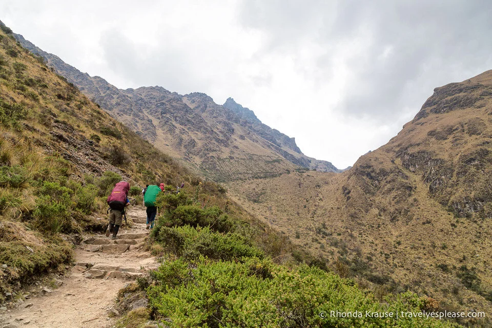
Inca Trail Hiking Details:
Location: Machu Picchu, Cusco, Peru
Length: ~27 miles (44km)
Time to Complete: 4 days
Difficulty: Moderate
Peru’s Inca Trail is a scenic, challenging, and historically significant trek through the Peruvian Andes. The ancient route is part of a larger network of Inca roads, at least 40,000 km long, that was built to connect the vast Inca Empire.
The classic 4 day hike starts in the Sacred Valley at the Urubamba River, 82 km from Cusco. The trail climbs into high altitude terrain then winds up and down the mountains, before finally arriving at Machu Picchu.
Over the course of its 44 km, the trail passes through cloud forests and alpine tundra, offering views of snow-capped peaks, distant rivers, and pre-Columbian ruins. At its highest point, the trail reaches 4200 m above sea level, so hikers may experience altitude sickness during the trek.
This hike cannot be done independently, as government regulations require that all hikers are guided by a licensed trekking agency. Tour operators obtain permits (only 500 are allotted per day), supply camping equipment and food, and employ cooks, porters and guides. The trail’s popularity and limited amount permits means that this trek needs to be booked months in advance.
May to September is the best time to do the hike, since that’s when conditions are driest. Before embarking on the trek, it’s recommended to spend 2-3 days in Cusco adjusting to the high altitude.
Contributed by Rhonda Krause, Travel? Yes, Please! – Read more about hiking the Inca Trail here.
Villarrica Volcano – Chile

Villarrica Volcano Hiking Details:
Location: Chile
Elevation gain: 3,280 feet
Difficulty: Difficult
I’ll be honest upfront. This is strictly climbing, not hiking. But stay with me. It’s not a technical climb, you only need the right equipment and stamina to walk up the 1000+ meters (3280+ ft) of altitude change. What makes it worth it is that, if you summit it, you’ll be on top of one of the few places in the world where you can see lava. You go to the peak of an active volcano!
In the Araucanía region in Chile you’ll come across Pucón, the country’s capital of adventure. One of the coolest things you can do there is to climb Villarrica Volcano. If you want to go on your own, you need to have climbing experience (a membership card to any mountaineering club will prove it). Otherwise you must go with a guide – there are plenty of options to join an organized trip in town, where you’ll also get all the equipment needed.
The volcano is 2847 m (9347 ft) high, and you can either start the climb from the foot of the mountain, or grab a cable car ride on the ski lift and start the ascent from approximately 1800 m (5900 ft).
The views through the whole hike are beyond amazing. You have the Chilean Lake District at your feet, which means that you get to see at least three lakes and the forest that surrounds them. Even if you don’t need stops to catch your breath, you’ll be stopping often to take photos.
From the summit you see the peaks of other nearby volcanoes, and enjoy the special experience of seeing fume and lava in the crater. As if this wasn’t cool enough, on the way down you can slide through canals carved in the snow!
Contributed by Coni, Experiencing the Globe – Read more about the Chilean Lake District here. https://experiencingtheglobe.com/hike-around-the-lake-district-and-climb-villarrica-volcano/
Best Hikes in Asia
Everest Base Camp – Kathmandu, Nepal

Everest Base Camp Hiking Details:
Location: Kathmandu, Nepal
Length: ~40 miles
Elevation Gain: ~8,000 feet
Time to Complete: 12 days
Difficulty: Difficult
It’d be hard not to argue that the trek to Mount Everest is one of the most iconic journeys in all the world.
It starts with the experience of Kathmandu, the capital of Nepal, which is a bustling city of over 1 million people. From there take the short but exciting flight to the village of Lukla at 9,383’. Lukla boasts one of the most thrilling airport runways in the world! Not only is the flight an exciting one, the views you are treated to during the flight are stunning.
Lukla is where the trekking starts, which will take you past quaint villages, farmland, and the Khumbu valley’s many teahouses. You will also pass and have the chance to visit some of the region’s beautiful monasteries. Be sure to take the time to learn the culture and customs. You will be entering Sagarmatha National Park where you need a park entry permit. You can buy your entry permit in Kathmandu or at the entry point to the park.
The traditional trek from Lukla to Everest Base Camp is roughly 40 miles. Though this doesn’t seem like a particularly long trek, don’t forget that you will be gaining over 8,000’ in elevation. It is recommended you proceed slowly and take the time to acclimatize. Most recommend taking 12 days to complete the round-trip trek to Everest Base Camp and back. There are numerous options for side trips and acclimation hikes to do along the way to EBC.
This will be one of the most memorable trips you ever do, the people are very nice and welcoming, and you will enjoy views you can’t get anywhere else in the world.
Contributed by Chris, The Bold Nomad
Lycian Way – Turkey

Lycian Way Hiking Details:
Location: Turkey
Length: 335 miles
Difficulty: Difficult
The Lycian Way deserves its iconic label for an array of reasons. The most important ones are probably the breathtaking scenery, the sometimes challenging hikes, and the fact that you’re walking timelines on Roman roads and old footpaths in ancient Lycia.
Where is the Lycian Way?
The Lycian Way runs from Fethiye to Antalya, on Turkey’s southern coast. Prepare for a 335- mile-long hike along the Lycian coast, divided into around 30 sections. Most sections of the walk are labeled with a medium-high difficulty level. The highest point is Mount Olympus’ summit at 1.47 miles. As this is an ‘alternative section,’ you can easily choose to bypass it or to hop on the cable car if you still want to enjoy the view. Speaking of views, they are mesmerizing almost 100% of the time. Pine clad mountains mixed with sea views and the ruins of 25 ancient sites, including UNESCO World Heritage sites.
How to get to the Lycian Way?
You can choose to walk the Lycian from Fethiye to Antalya, or the other way around. Know that most guidebooks cover the hike leaving in Fethiye. Whichever departure point you choose, it is easily accessible by car or public transportation. You can fly into Dalaman for a Fethiye departure, or land at Antalya airport if you’ve decided to walk in the opposite direction.
Important things to know when hiking the Lycian Way
You do not need a permit to hike the Lycian Way. Proper preparation, sturdy walking shoes, and ample sun protection combined with plenty of water should suffice. Lycia is hot in summer, but fortunately, the sea is never far away. Still, spring or autumn are ideal for hiking the Lycian Way.
Contributed by Pascale Van Craeyveld, Slow Travel Guide – Read more about the Lycian Way here.
Lake Ala Köl – Kyrgyzstan

Lake Ala Köl Hiking Details:
Location: Kyrgyzstan
Time to Complete: 4 days
In the heart of little visited Central Asia is a hiker’s mecca. A country where over 90% of the land is mountains. And in those mountains is one of the most spectacular lakes in the world - Lake Ala Köl.
To reach Lake Ala Köl you will need to head to the capital of Kyrgyzstan, Bishkek, and make your way east via shared taxi or marshrutka to the small town of Karakol. This is the base to start and finish the four day hike into the Terskey Alatau mountain range. In recent years this four day hike has become the most famous and popular hike in Kyrgyzstan for good reason.
Day one is a relatively easy hike up the Karakol valley through forests, past rushing streams and wild horses. Yes, wild horses!
On day two be prepared to climb as you’re headed up into the mountains and Lake Ala Köl itself. This alpine lake is a huge turquoise expanse sitting nestled beneath jagged mountain peaks. The colour is simply stunning and made me think of a giant turquoise gem. As you skirt the lake you continue climbing up a scree path towards the high pass at 3860m The views here are breathtaking. The path down the other side is a wild loose rock affair down towards the Kel’Deke Valley.
Day three is spent making your way down through the trees and alpine meadows making friends with more wild horses until you reach Altyn Arashan. This small hamlet is overlooked by the famous Pik Pilatka mountain and has some small guesthouses. More importantly, there are hot springs to soak your tired, sore body which is a very welcome respite. After two strenuous days, the last day of the hike is relatively easy following the river down the valley.
This four day trek can be done independently if you are experienced at multi day hikes and hiking at altitude, but do your homework. A small entrance fee is payable and hiking is limited from June to September.
Contributed by Carly, Carly’s Adventures Afar – Read more about the Lake Ala Köl here
Mt. Fuji – Japan

Mount Fuji Hiking Details:
Location: Japan
Time to Complete: ~10 hours
Difficulty: Difficult
One of the most iconic and easily-recognizable mountains in the world is Mt. Fuji. With its distinctive cone shape, Japan’s tallest mountain has been the inspiration for countless works of art. Many Japanese consider climbing Mt. Fuji to be a pilgrimage of sorts, and for me and my husband, it was an honor to partake in the tradition.
The hike up Mt. Fuji offers stunning views of the surrounding mountains, and on a clear day, you may be able to see as far as the ocean. Many climbers choose to spend the night in one of several mountain huts near the summit so that they can see the sunrise. We chose to do the entire trek in one day starting in the early morning, and we were not disappointed! Round trip, including breaks and about 45 minutes at the summit, our Mt. Fuji climb took about 10 hours.
Mt. Fuji stands at over 12,000 feet, but few hikers start at the bottom of the mountain. There are four main trails leading to the summit, and each is divided into about a dozen “stations.” The official starting point on all four trails is the 5th Station. The trails range in length, altitude gain, and difficulty.
The climbing season for Mt. Fuji is very short: generally, from July to early September. You do not need any special permits, but the short season can lead to big crowds, especially on weekends and during the Obon holiday (mid-August). Aim to climb on a weekday and avoid Obon week altogether.
If you love to travel and want to experience the world’s best hikes, Mt. Fuji should be at the top of your list! It’s a challenging – but not technical – climb that you can easily incorporate into your visit to Japan.
Contributed by Stephanie Montague, Poppin’ Smoke –Read More about Mount Fuji here
Baegundae Peak – Seoul, South Korea
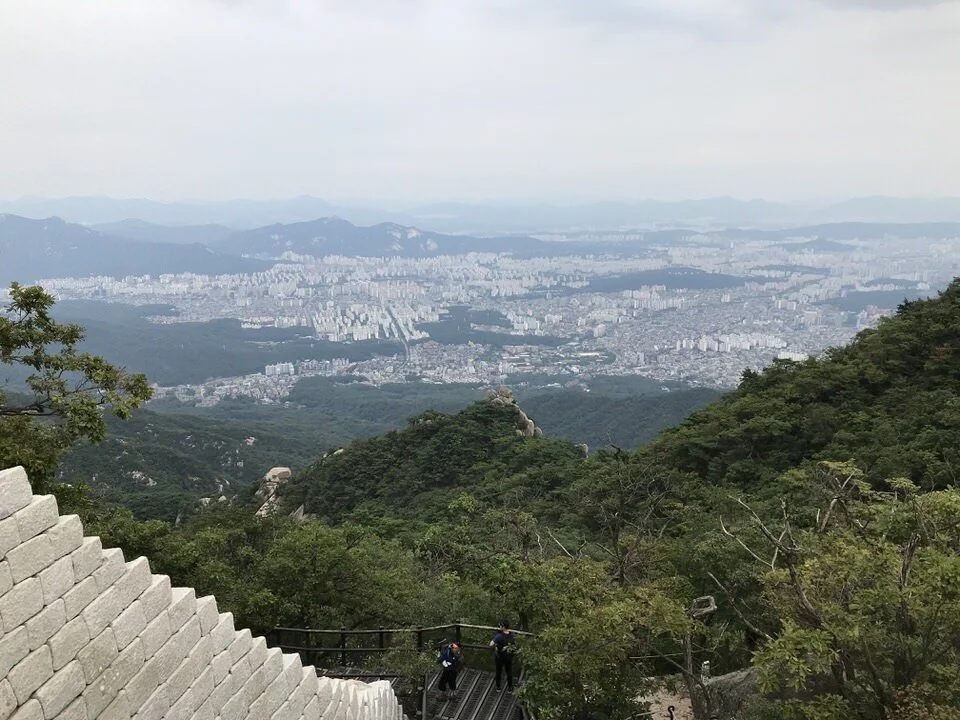
Mt. Bukhansan Hiking Details:
Location: Seoul, South Korea
Length: ~2 miles
If you are looking for a slice of nature while exploring the metropolis of Seoul you can escape to Bukhansan National Park. The park is located just north of the city and it is one of the most popular hiking spots for hiking lovers of Seoul. There are plenty of great day hike options and it’s incredibly easy to get to using Seoul's public transit options.
The gem of the park (and the most popular hike) is to Baegundae Peak, which stands at 840 m (or 2700 ft) above sea level and is the highest mountain in the park. You can reach the summit via several trails after about 3.5 km of uphill hiking. The trails are rated at medium-hard difficulty and there are many rocks, but you’ll see every level of hiker out on the trail.
From the top you’ll have well-deserved panoramic views of Seoul. There is a large rock area at the top where you can relax and refuel before descending down the same route or to the other side of the mountain where you can take public transportation back to the city.
Contributed by Rand, Well Traveled Mile
Ijen Crater – Indonesia
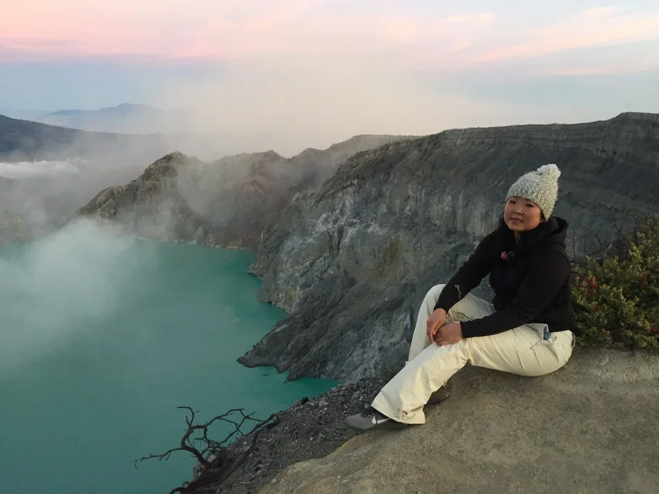
Ijen Crater Hiking Details:
Location: Indonesia
Time to Complete: 2 hours
There has been a tremendous increase in tourists looking to hike up Mount Ijen to its crater in the past few years. Mount Ijen is an active, but dormant, volcano famous for the world’s largest acidic lake and working Sulphur mine. It sits on the border between the Banyuwangi Regency and the Bondowoso Regency in East Java, Indonesia. Mount Ijen can be reached from either Bali or from Surabaya, though the drive to the bottom of Mount Ijen takes about 1.5 hours from Banyuwangi along super windy roads. There is an entrance fee of about USD10 for foreigners, and the hike can be done without a guide.
The hike up to Ijen Crater is anywhere from 1.5 to 2 hours reaching an elevation of 9,183’. It is up super steep terrain in the dark, but the paths are well marked and there are porters that can take you up if you feel so inclined – plus you’ll be hiking up with loads of other people so there is no chance of you getting lost.
Once you’re up by the crater, you have the option of heading down to the sulphur mine to try and catch the blue flames. The terrain down is quite treacherous as it’s over sharp rocks; if you have a guide, they can help you down. A sulphur mask is a must if you intend to go down! If you skip this portion of the hike, then you’ll carry on to the top where you’ll (hopefully) be rewarded with a magical sunrise of pinks and purples! It was one of the most amazing hikes of my life, it was pure magic!
Contributed by Julie, Jewels Wandering
Thousand Lion Mountain – China

Thousand Lion Mountain Hiking Details:
Location: China
Difficulty: Difficult
Looking to escape the hordes of fanny packs at the Great Wall outside Beijing or the ancient terra-cotta warriors near Xian? Thousand Lion Mountain could be your respite.
My stomach got a cramp just looking at the worn marble steps climbing the 9,120-foot mountain that disappeared into a fluffy gray cloud. Thousand Lion Mountain, between Dali and Lijiang to the north in China’s remote Yunnan Province, is a popular weekend spot for Chinese families from the surrounding areas. Depending on the trail, 800 to 1,000 stairs lead to the mountain peak past 2,500 stone-carved lions dating to the Song (906-1279) and Qing (1644-1911) dynasties. Along the way, you’ll pass towering lion carvings, an important tradition in China. The Chinese believe that lions are great protectors. Today, you’ll see them guarding holy sites and entrances to towns.
One thing is certain – you’ll feel the burn after this hike. After three hours of climbing the stone staircase, the trail levels off and winds along a sacred monastery, a popular spot for local Buddhists. It’s often packed with elderly men and women cooking meals, and they are happy to share their feast.
From here, it’s just about an hour to reach the top, where you’ll be rewarded with a view of a gorgeous white brick pagoda on the peak. Below it stands the hike’s largest carving, a 60-foot-tall marble male lion. As you take in the incredible view of the valley, you can’t help but feel completely transported to a whole new world.
Thousand Lion Mountain is less than a 10-minute drive northwest from Jianchuan. No permits are needed, but you will need to purchase entry to the park (approximately $2.80 USD per person). The park is open daily from 8 a.m. to 6 p.m.
Contributed by Phil Zimmerman, Gourmet Globetrotter
Hampta Pass Trek – India

Hampta Pass Trek Hiking Details:
Location: India
Length: ~16 miles
Highest Elevation: 14,000 feet
Time to Complete: 5 days
Best time for Trek: June to October
Difficulty: Easy to Moderate
Hampta Pass Trek is one of the best beginner treks of the Himalayas. When you reach the top of the Hampta Pass from the Manali side, the view is entirely different from the other side (i.e. Spiti) which is mostly and cold desert.
The beautiful trek is surrounded by gorgeous waterfalls, various flowers, and maple trees. To reach the base camp first you have to reach Manali. The nearest airport to Manali is Bhuntar, around 50 km from Manali. Alternately, you can take Volvo buses to reach Manali from Delhi.
From Manali, the base camp Jobra is around 30 km. Once you reach it, the trekking starts. No permits are required for this trek, but you must keep in mind that no tent rental services will be available on the way from Jobra to your first campsite, Chikka. Rent tents from Manali itself. Also, no restaurants are on the way, so you must carry your own cooking utensils and cook your own food. You can also hire porters to carry your luggage.
At the beginning of the trek, you can see clear trails, but gradually they decrease as you ascend up. The view and scenery keeps changing along the trek. The trails are covered with beautiful flowers, and you will get to cross a very old wooden bridge. The place is so serene and silent that you can hear the streams gushing down the mountains and the birds chirping.
It is a wonderful experience. You should definitely go on this trek.
Contributed by Shalini Garnaik, Eager 2 Travel
Adam’s Peak (Sri Pada) – Sri Lanka
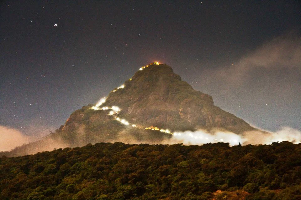
Adam’s Peak Hiking Details:
Location: Sri Lanka
Highest Elevation Gain: ~7,359 feet
Difficulty: Moderate
Adam’s Peak, also known as Sri Pada among religious pilgrims, is in central Sri Lanka with its peak at 2,243m (7,359 ft) above the sea level.
The best thing about hiking to Adam’s Peak is that it can be done within a day. Hiking usually starts at midnight and when the sun rises you can take breathtaking views from the peak. From a difficulty point of view, it is easy to complete. You do not need to worry about bad weather, slippery, rocky treks. But, you need to have good strength to climb a total of 5000 to 6000 stairs to reach the top. I would recommend carrying a trekking pole with you for extra support.
At the top, there is the rock which resembles the feet of Lord Shiva (Sri Pada) according to Hindus, while according to Buddhists, it is of Lord Buddha, and according to Muslims/Christians, it is of Adam, hence the name.
The best way to reach Adam’s Peak is from the nearest town, Dalhousie. To get to Dalhousie, you will find easy transportation by taxi, tuk-tuk, train or bus from any major city. If you plan to visit Adam’s peak, January to the first week of April is the best time, but avoid full moon days and weekdays when locals usually visit for offerings.
Contributed by Ankurman Handique, Wandering Minimalist
GRAB MY ULTIMATE OUTDOOR ADVENTURE STARTER KIT
I created an awesome Outdoor Adventure Starter Kit for you (for FREE). It's filled with 14 pages of hiking, backpacking and rock climbing tips, techniques and inspiration to help you hone your outdoor adventure skills and become the ultimate outdoor badass. You can get immediate access to it below. What are you waiting for?
Best Hikes in Africa
Machame Route, Mt. Kilimanjaro – Tanzania
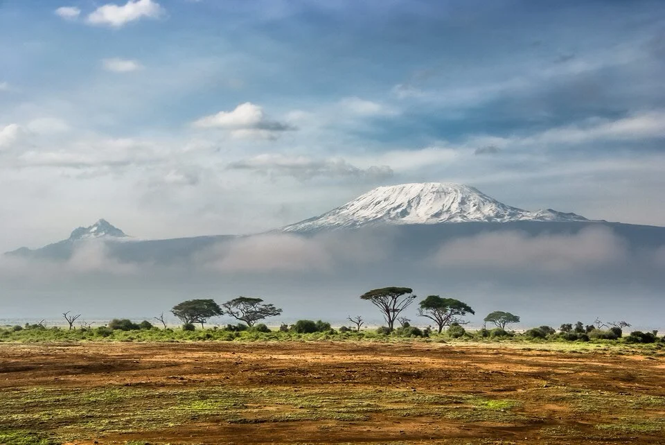
Mt Kilimanjaro Hiking Details:
Location: Tanzania
Length: ~37 miles
Highest Elevation: ~19,340 feet
Time to Complete: 5-6 days
Difficulty: Difficult
Kilimanjaro is the world’s highest free-standing mountain at 19340 ft (5895m), the roof of Africa, the hike that cemented my love for this continent.
The six routes to Uhuru Peak boast different scenery, difficulty and success rates (as well as length and cost). There is no one best route; you must select according to your experience, fitness and preferences for sleeping arrangements and terrain, as well as your budget and schedule.
I chose the 6-day/5-night Machame Route, also known as the tougher ‘whiskey route’ to Marangu’s ‘coca-cola route,’ because I wanted as much scenic variation as possible, I was confident in my hiking ability but also wanted to allow for acclimatisation, and I enjoy being in nature. It did not disappoint; the scenery is incredible and every day is a different experience.
Like most people attempting this route, I travelled from Moshi to Machame Gate on the morning of my first day, where I met my group’s guide, porters and chef. Ahead lay a 37-mile trek with a total elevation gain of 13960 ft.
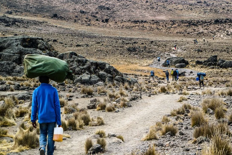
All trekkers must be accompanied by a registered and licensed guide. When you book your climb, all park entrance fees, permits and camping/hut fees will be included. Please note that shopping around for the cheapest deal is likely to result in either a skeleton team on the mountain (which I strongly advise against) or your porters, guides, chef and toilet cleaner (yes, someone has to do it) being underpaid. It’s worth it to pay a little extra and please be aware that tipping your trekking crew at the end of your hike is customary.
I am left with so many wonderful memories of Kilimanjaro, and while of course some of these are of the breathtaking scenery, the sense of achievement on reaching Uluru Peak, and the thrill of camping above the clouds, my memories of the people who work on the mountain are those that make me smile the most. The beat of the song, ‘Jambo, jambo bwana…’, still echoes through me.
I remain grateful to Good Luck, one of the younger guides I met, for walking behind me on summit night and grabbing my backpack to shift me upright everytime the altitude and exhaustion threatened to keel me over; to Frankie for always having a smile and a joke; to chef Ricky for encouraging me on from Stella Point when all I wanted to do was sleep; to all the guys who, with backpacks (yes, plural) on their head and old trainers on their feet, sped past me and all the other hikers with wise words “pole pole” (‘slowly, slowly’). Yes, indeed, take your time on Kilimanjaro, not just to better your chances of success, but to savour it. It is truly a special mountain.
Contributed by Joss from Little Green Globetrotter
Dana to Petra – Jordan
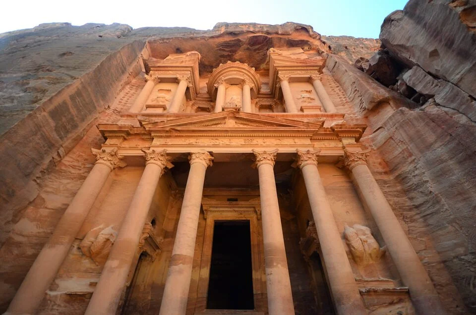
Dana to Petra Hiking Details:
Location: Jordan
Length: ~44 miles
Time to Complete: 4-5 days
Dana to Petra is considered one of the world’s best hikes according to National Geographic and one of the best things to do in Jordan for outdoor lovers! The Dana to Petra hike is just one of many great hikes that you will find in Jordan and by far, the most popular hike in the country. They even have a route network from the northern tip of the country to the southern tip at the Red Sea (over 400km long). The trek itself is 4 to 5 days and 72 km long, although you can do parts of it as day trips.
The Dana to Petra highlights include views of Dana reserve from the top, before descending into the Araba valley and the opportunity to stay at one of the best eco-hotels in the world, Feynan Ecolodge. Entering Petra without tourists by the “back door” from Little Petra is another one of the highlights, with a visit to Petra’s Monastery and then the rest of Petra itself!
If you take this hike on a Jordan tour, you have a range of accommodation options, with the tour company setting up wilderness camping along the way. If you plan to do the hike alone, it is suggested to hire a local guide, as the route is not marked. There are fees to enter Dana Biosphere Reserve. A pass to Petra is also required and must be purchased from the visitor’s center in advance, though this route does not enter via the visitor’s center. Instead, this hike starts at Dana Village. Hiring a private vehicle is the only way to get there (unless you are on a tour).
Contributed by Lindsay, Step into Jordan
Lion’s Head – Cape Town, South Africa

Lion’s Head Hiking Details:
Location: Cape Town, South Africa
Length: ~7 miles
Elevation Gain: ~2,200 feet
Time to Complete: 2-3 hours
Difficulty: Moderate
Cape Town is the kind of place that’s easy to fall in love with: a lively city with beaches, safaris, and mountains all within easy reach. Two of those mountains - Table Mountain and Lion’s Head - actually sit within the city itself. Most visitors will climb (or more likely, take the cable car) to the top of the former, but the latter shouldn’t be overlooked. In fact, it’s one of the most beautiful hikes I’ve ever done.
At 669m total elevation and 5.5km each way, Lion’s Head is a fairly easy hike with patches of moderate intensity and one of the best day hikes in the world. If you want an easier hike, you can park your car halfway up and start at the good part. At some parts, you can even choose between longer but flatter route, or a harder vertical ladder. In total, you could easily ascend and descend in just a couple of hours, but it’s the kind of hike you’ll want to set aside the entire afternoon for.
The Lion’s Head trails snakes around the outside of the mountain, giving you 360-degree views of the city, the beaches and the sea. That means there are endless photo opportunities and you’ll want to stop often to simply take it all in. If you want to witness a breathtaking view of Cape Town and Table Mountain, start your hike up Lion’s Head mid-afternoon and enjoy the sunset from the top - you definitely won’t forget it!
Contributed by Jodie, Alajode
Best Hikes in Europe
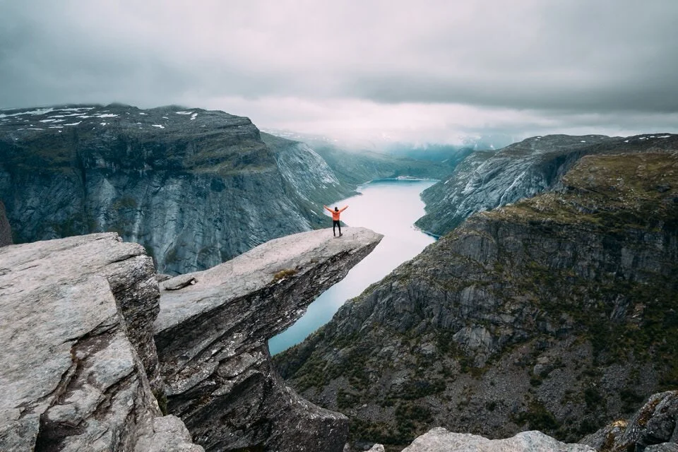
Kjeragbolten – Norway
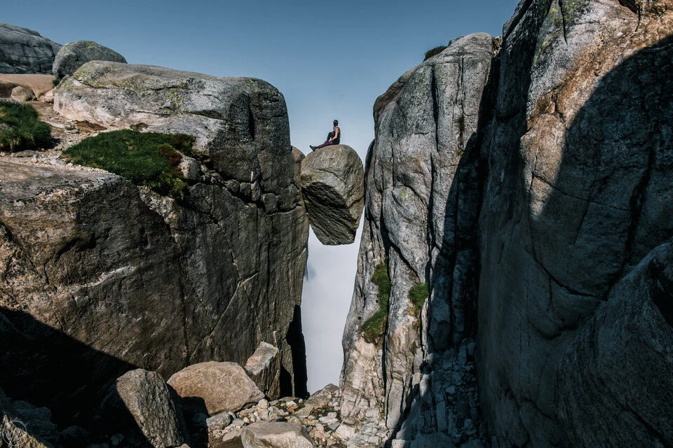
Kjeragbolten Hiking Details:
Location: Norway
Length: ~6 miles
Highest Elevation: ~3,550 feet
Time to Complete: 5 hours
Difficulty: Modeerate
The Kjerag hike in Norway is one of the most popular hikes in the area, and for a reason, and Norway alone is one of the best places to hike in the world. Kjerag is the name of the mountain, towering 1084 meters above the Lysefjord, allowing for the beautiful views of the surrounding mountains and the waters of the fjord below.
However, more than just the beauty of Kjerag made this place so popular – it was also a stone called Kjeragbolten. Kjeragbolten is a massive boulder wedged between two cliffs, hanging almost 1000 meters above the waters of the fjord. This is what brings the crowds of the fearless hikers into the area. If you are brave enough, you can step on the boulder. It is not as hard as it looks, but if you suffer from fear of heights, it is not recommended. The Kjeragbolten hike is still worth doing, even if you don’t step on the rock – you have wonderful views along the way.
Kjeragbolten is located about a 6-7-hour drive from Oslo. For an easier way of getting to the trail, you can drive or take a ferry from Stavanger. The hike is 9.8 km long and takes around 5 hours in total. The path is mainly on the barren rock and is quite steep in places. Thankfully, there are chains to support you while going up or down. To step on the famous rock, you need to go behind it and wait for your turn on the 1-meter path. After that, just make a big step, and you are on the rock! You can find more details about Kjerag hike and how to step on the rock, as well as how to take pictures of it in the link.
Contributed by Aga, Worldering Around – Read more about the Kjerag hike here
Caminito del Rey – Spain

Caminito del Rey Hiking Details:
Location: Spain
Length: ~5 miles
Highest Elevation: ~1,360 feet
El Caminito del Rey is a spectacular hiking trail in the middle of the Andalucian mountains and one of the top hikes in the world. The path is pinned along the steep walls of a narrow canyon in El Chorro, near Ardales in the province of Málaga, Spain. From the track, you will see turquoise lakes, mountains, gorges and valleys. It is a short hike, but the views are of the most spectacular in the world.
The walkway was constructed between 1901 and 1905 when hydroelectric power plants were built in the area. Although nowadays the walk is perfectly safe, this used to be one known as one of the most dangerous path in the world. The partially concrete road deteriorated over the years. Some parts completely collapsed, resulting in five deaths in 1999 and 2000. The walkway re-opened in 2015 after an extensive renovation. Subsequently, Lonely Planet listed it as one of the best attractions for that year.
The route is almost eight kilometres 7.7 km long (4,8 miles), of which nearly half is boardwalks. The highest point is at 417 metres, and the lowest is 233 metres.
The route is linear, not circular. Visitors can start at either side. Then you walk back or take the bus, which shuttles with regular intervals between the northern access point in Ardales to the southern one at El Chorro in Álora, or the opposite. A ticket costs € 1.55. To get there either drive or take the train from Malaga or Seville. Get out at El Chorro station. Tickets sell out far in advance, so plan ahead.
Contributed by Stefania van Lieshout, Views of the World
Sentiero Azzurro – Cinque Terre, Italy
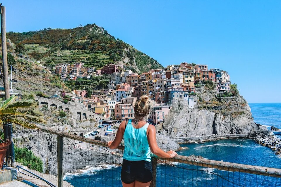
The Sentiero Azzuro Hiking Details:
Location: Cinque Terre, Italy
Length: ~7.5 miles
Elevation Gain: ~1,640 feet
Difficulty: Moderate
The Sentiero Azzurro hiking trail in Cinque Terre is one of the most scenic and beautiful hikes in Italy and the world. The Sentiero Azzurro, meaning "Blue Path" in English, connects the five towns of Monterosso, Vernazza, Corniglia, Manarola and Riomaggiore (hence the name Cinque Terre, or "Five Lands") and is famous for its stunning views over the sea.
The total length of the path is 12km with a 500m elevation gain, and it goes in and out of the five towns. Finding the beginning of the trail from the towns can be a bit tricky at times, since you'll have to wander around the narrow alleys a bit, but once you're on the actual trail it's well marked and pretty straight forward. The terrain however is mostly dirt and rocks, so make sure to wear appropriate footwear!
The Sentiero Azzurro is part of the Cinque Terre National Park and you will have to pay an entry ticket to hike it. Tickets are 8 EUR for walking-only access to the park, or 15 EUR if you want the hop-on/hop-off option with the local trains. There are stalls at the start and end of each section of the trail where they check tickets and where you can purchase one. There are other towns and hiking trails in the national park, but the Sentiero Azzurro is the most famous.
The whole trail can be done in one day, with stops at each of the five towns to enjoy a quick break for an Italian gelato, focaccia or a quick swim in the sea. The hike itself is extremely beautiful and varied, with stunning views all throughout. At times you'll be walking amongst the vineyards and other times you'll be walking right along the edge of the cliffs, with the steep rock face on one side and the sea on the other.
What makes the Sentiero Azzurro unique, however, is the distinctive coloured houses of the Cinque Terre towns. These are visible from different angles and viewpoints during the hike. I love this hiking trail because there are stunning views all throughout, not only once you reach the peak or end point as is often the case.
Contributed by Greta, Greta’s Travels – Read more about the Cinque Terre here
Ancient Road – Jutland, Denmark
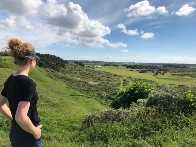
Then Ancient Road Hiking Details:
Location: Jutland, Denmark
Length: ~310 miles
The Ancient Road, which the Ice Age created, runs more than 500 kilometers through Jutland, Denmark, and is divided into several shorter stages which are approximately 20 kilometers per stage. You can hike it or ride your bike – it is two different paths, but they go through pretty much the same areas.
The stage that I hiked is 26 kilometers and goes from Fjerritslev to Tranum. You can get to the starting point by bus or a public taxi service (FlexTrafik) or take your own car. Since it isn’t a loop hike you can book the public taxi to take you back to the starting point.
During the hike you pass stunning woodland, amazing ocean views, and hills where horses and sheep grass quietly in the sunshine. The chalk cliff “Svinklovene” has been created by rainwater running down the cliff that now looks like cloven hoofs. When you are at the top it feels like you are on the top of the world. The view is breathtaking, and time just stops.
The Ice Age created the ridges you hike on top of along the coast, which have amazing views of the ocean and the wide and never-ending beach. After a while you reach a valley that looks like something from Jurassic Park, and after a few more kilometers you reach the valley of Fosdalen, which reminds me of the jungles in New Zealand with big trees and ferns.
In Tranum, as you get closer to the end of this stage, you descend into the forest. Here you will find a shelter, a playground made of nature’s own materials, and several firepits.
The stage of the Ancient Road takes you through so many natural wonders in such a short hike. If you want to hike in Denmark, experiencing as varied nature as possible, this stage of the Ancient Road is the place to go. If you can walk 10 kilometers, this hike is for you. It is not that difficult although it can make you sweat a little bit.
Contributed by the Curly Camper
Camino de Santiago – Spain

Camino de Santiago Hiking Details:
Location: Spain
Length: ~500 miles
One of the oldest and most iconic hiking trails in the world is the Camino de Santiago in Spain. The trail originated over 1,000 years ago as a Christian pilgrimage to the town of Santiago de Compostela where pilgrims would pay their respects to the remains of St. James. Back then, pilgrims would come from all over Europe and begin their walks from their front door.
Nowadays, there are over eight well-known Camino de Santiago routes. The traditional route is the Camino Frances. It begins in a town bordering France, and the distance is 500 miles. However, pilgrims are welcome to walk their own route even if it’s not official. All of the routes vary in distance and difficulty. Pilgrims must carry a permit called a credential, which will be stamped at albergues and bars along the way.
The Camino is not a typical hike where you need to carry camping gear and supplies. There are albergues along the way where pilgrims can sleep. These are essentially hostels for hikers, but many of them are churches that have been renovated to accommodate pilgrims. Most albergues have kitchens where pilgrims can cook. The bars in town also typically have pilgrim meals that include several courses, bread, and wine.
The Camino can be walked anytime of year. There are fewer bars and albergues open in the winter, but there are also far fewer pilgrims. In the summer months, the Camino is so busy that albergues are packed full. Spring or fall would be an ideal time to walk the Camino to avoid the crowds and have good weather.
A favorite part of the Camino de Santiago experience for many is the camaraderie between pilgrims. People come from all over the world to do this walk, and it’s easy to meet people and share experiences.
The Camino de Santiago would be a perfect trail for hikers who are looking for a cultural experience, delicious food, a bed every night, and to make friends from many different countries.
Contributed by Megan Maxwell, Mountains with Megan – Read more about the Camino de Santiago here
South West Coast Path – England
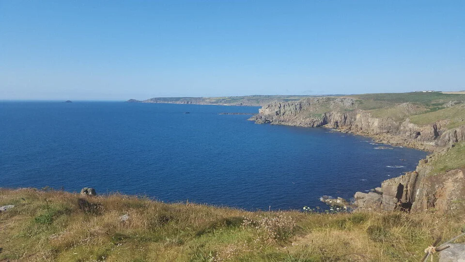
South West Coast Path Hiking Details:
Location: England
Length: ~630 miles
Iconic among walkers, the South West Coast Path is THE way to see England on a long distance hike. It takes you through a section of the island that is known for its temperate weather, featuring a very high concentration of beaches (some famous for surfing), cute fishing villages and gorgeous country lanes. Basically, it's exactly where you want to be walking. And although the British weather is always a gamble, this is the part of the country most likely to give you sunshine.
As if it needed any more of a claim to fame, it's England's longest way-marked path. It starts at Minehead in Somerset and doesn't end until Dorset's Poole Harbour. So why not spend a few days in Cornwall?
It stretches over 630 miles and is very easy to join - with the path unfenced, so that you can hop on almost anywhere you like. It often crosses National Trust land, such as on Burgh Island, so you can join after a few hours visiting a classic property, or beside beaches, whose car parks you can use. You don't need any special skills or permits, so you can just get going.
It is worth booking accommodation ahead before you go (wild camping in England is not legal) and bringing clothing for all weathers, along with sturdy walking boots for all terrains.
Contributed by Danni, Live in 10 Countries
Vikos Gorge – Greece

Vikos Gorge Hiking Details:
Location: Greece
Length: ~7 miles
Difficulty: Easy to Moderate
Vikos Gorge is the deepest gorge in relation to its width in the world, and, along with Samaria Gorge in Crete, they are the two most popular hiking destinations in Greece. This amazing landscape has been dug into the rock over the course of millions of years thanks to the River Voidomatis. Beyond being just an amazing trail, it’s also a rich ecosystem of impressive biodiversity.
The 12 kilometer trail is of easy to moderate difficulty with no technical parts except for a very small section where a little scrambling is needed, but there are ropes to help steady yourself. The only real danger you may encounter on the trail of Vikos Gorge is rock fall, which usually takes place during rain, so if there is a chance for rain, it’s better to leave it for another day.
The most common direction to hike is from south to north starting from Monodentri and finishing at Vikos village. This route is mostly descending with the exception of the final ascent to Vikos village where you will find some amazing vantage points to take photographs. From there you will get a better view of the amazing rock formations on the eastern rock known as the Towers of Astraka.
A longer alternative route is to keep hiking along Voidomatis all the way to its springs and then turn north towards the peak of Astraka and finish at Mikro Papingo village—a longer and more difficult hike. The trail is well signed and you can hike Vikos most time of the year except for winter and early spring when the river level is still high.
Contributed by Chrisostomos Kamberis, Trip & Trail – Read more about Vikos Gorge here
Plitvice Lakes National Park (Trail C) – Croatia

Plitvice Lakes National Park Hiking Details:
Location: Croatia
Length: ~5 miles
Highest Elevation: ~1109 feet
Time to Complete: 4-6 hours
Difficulty: Moderate
Plitvice Lakes National Park in Croatia has some of the most beautiful hiking trails in the world. The beautiful landscapes with lakes and waterfalls in the valley are a sight to be seen, and there is no better way to see them than on a hike!
Hiking at Plitvice Lakes National Park is super easy, just pay admission to the park, and you are free to hike as you please. Admission also grants you a tram and boat ride, so you can rest your legs while strolling the paths.
Our favorite hike in Plitvice Lakes National Park is Trail C which takes you around the Instagram-famous Lower Lakes as well as the beautiful Upper Lakes. This hike will take you through every single one of the gorgeous lakes and flowing waterfalls of the park.
Trail C is approximately 5 miles (or 8 kilometers) and takes between 4 and 6 hours depending on your fitness level, time spent taking the boat, and whether you opt to take the tram on the way back. The boat, included with the admission price, will take you across Kozjac Lake between the Lower and Upper Lakes.
For a hike in a mountainous area, the elevation gain on the hike is not super extreme. The entire hike only climbs approximately 1,109 feet or 338 meters.
Regardless of the hike you choose at Plitvice Lakes National Park, they are all beautiful and 100% worth your time. Every single lake and waterfall we saw was amazing!
Contributed by Constance, The Adventures of Panda Bear – Read More about hiking in Croatia here
Wicklow Way – Ireland
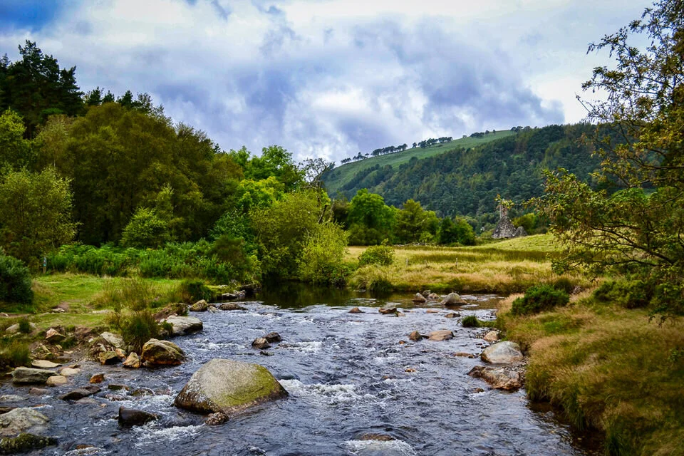
Wicklow Way Hiking Details:
Location: Ireland
Length: ~79 miles
Highest Elevation: ~10,500ft total gain
Time to Complete: 1 week
Difficulty: Moderate
The Wicklow Way in Ireland is one of my absolute favorite hikes on the planet and one of the best walks in the world. It is 79 miles of iconic Irish countryside—with some misty mountains thrown in for good measure. Almost anyone interested in a long distance hike could manage this one, despite the decent elevation gain in these mountainous sections. Its proximity to Dublin, plus the option to mix tent camping with bed and breakfasts as you see fit, make the Wicklow Way a perfect choice for novice and skilled backpackers alike.
The hike starts in Dublin in the North, ending in Clonegal village in the South. Of course, you can choose northbound or southbound—I recommend the latter because the elevation gain is a bit easier. As you head North, you gradually encounter steeper daily climbs. The highest point is about 1900ft/600m, so not too high for elevation sickness but high enough for ridiculously beautiful views.
The Wicklow Way typically wouldn’t take more than a week for most backpackers. There are plenty of villages along the way for lodging, as well as some wooden shelters on the trail. While possible, I wouldn’t camp every night on the Wicklow Way; there are long stretches of private land where camping isn’t allowed. Besides, warm meals and hot showers in B&Bs are heavenly after hiking in the rain!
Other than essential rain gear, water, snacks, and basic trail first aid kits, you don’t need to worry about carrying a ton of gear. You can stock up on pretty much everything in villages along the way. My favorite stop is Glendalough, where you walk through lakes and ruins, and Park Rangers educate the public on the area’s history. That said, I genuinely loved every footstep I took on this trail!
Contributed by Kaisa, Glam Granola Travel – Read more about hiking in Ireland here
Dolomites – Italy
Dolomites Hiking Details:
Location: Italy
Length: ~1.2 miles
Time to Complete: 2 hours
Difficulty: Moderate
One of the most beautiful and iconic hikes I’ve ever done was through the heart of the Dolomites, the beautiful mountain range and UNESCO World Heritage Site. The hike is moderate in difficulty level, is 2 km (1.24 miles) long, and takes at least 45 minutes one way.
Start in the small ski resort town of Carezza and get on the Paolina chairlift up to Rifugio Paolina (2,125 meters above sea level). Once at the top, take Path No. 539 (on the right) and start the hike upward. Be warned, the beginning is quite steep, but the views are incredibly rewarding. You’ll be left in awe as you make your way through winding pastures and get a full view of the Latemar mountain group.
Stop for a few photos at the bronze eagle monument, dedicated to Theodor Christomannos, a keen mountaineer and pioneer of tourism in the Dolomites. From the eagle forward, the path is quite flat as it turns a corner and reveals a valley full of breathtaking views. According to our guide, millions of years ago, this area was a coral reef and completely underwater. It’s hard not to think about that and try to imagine it as you look around at the unique jagged edges of the peaks that surround you. It’s quite magnificent.
Not far off from the eagle statue, you’ll see the Rifugio Roda di Vael mountain hut (2,283 m) in the distance. If you’re doing the hike in the morning, you can easily have lunch here and turn back the way you came back to Carezza.
If you’re looking for a prolonged adventure, I recommend spending the night at Rifugio Roda di Vael and continuing the hike through the Catinnacio mountain group (Path No. 545) towards Vigo di Fassa and the Ciampedie cable car the next day. The hike is approximately 2.5 hours. The hut is open during the summer season from the end of May to mid-October. Call ahead to confirm it’s open if you’re planning on eating or staying there.
Contributed by Ioana, The World is My Playground – Read more about the Dolomites here.
Grab my [Free] Hiking Packing Checklist!
Best Hikes in Oceania
Overland Track – Tasmania
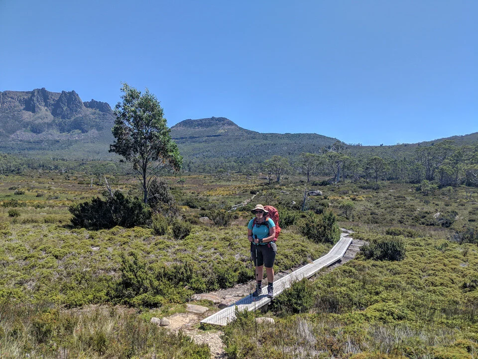
Overland Track Hiking Details:
Location: Tasmania
Length: ~50 miles
Time to Complete: 6-7 days
Difficulty: Moderate
You’ll find Tasmania’s Overland Track on every list of the best long-distance hikes in Australia. It’s an 80km (50 mile) thru-hike across the mountains in the center of Tasmania’s World Heritage Wilderness area. It protects the rare southern temperate rainforest and hosts lots of unique Tasmanian wildlife.
The hike starts at Cradle Mountain National Park, then works its way south across an undulating plateau. Along the way, you can take side trips to see spectacular waterfalls or climb several peaks, including the highest one in Tasmania: Mount Ossa. The trail finishes at Lake St. Clair, Australia’s deepest lake. Most hikers take 6 or 7 days to complete the trek.
Hikers stay at basic huts or campsites along the way. The huts and campsites are about a day’s walk apart, so you’ll end up making friends with other hikers on the same schedule.
It’s a popular trail, so you do need to make advance reservations if you plan to hike between October and May (the summer months in Australia). Permits cost $200AUD (about $137USD) per person. You’ll also need to buy a National Parks Pass.
Since it’s a point-to-point hike, the easiest way to get to and from the trail is via a shuttle van from the major cities of Hobart or Launceston. You can also shorten your hike by taking a water taxi across Lake St. Clair instead of hiking along the shore. That option will save you about 15km (9 miles) of travel.
Contributed by Taryn, Happiest Outdoors – Read more about the Overland Track here
Bibbulmun Track – Australia

Bibbulmun Track Hiking Details:
Location: Australia
Length: ~620 miles
Time to Complete: 7 weeks
Difficulty: Difficult
The Bibbulmun Track in Western Australia is one of the most memorable things I have ever done. This long-distance hike stretches for a tad over 1000 km (620 miles) from Kalamunda (Perth) to Albany (or visa-versa) and traverses a wide range of terrain including forests, shrub-land, coastal areas, and more.
It took a little over 7 weeks for me to complete, but you can easily do smaller sections of it to fit however much time you have to spare. Although the track is accessible all year round, the best time to walk it is during the wildflower season, from September to mid-November.
There are a few ways for you to enjoy the track. Experienced hikers can DIY it while taking advantage of the many campsites along the way. If you prefer a bit of comfort and/or day hikes, you can stay in the towns nearby the track, most of which are worth a visit on their own. Some of my favorites include Dwellingup, Walpole, and Peaceful Bay. Guided tours are also available, including informational day hikes where you can learn about the native flora and fauna.
No matter how long you go for or how you do it, the Bibbulmun Track will stick in your memory and is a fantastic way to explore the South West of Australia.
Contributed by Bert Luxing, Survival Fitness Plan
I hope you enjoyed this list of the best world hikes according to top adventure and travel bloggers! If you have a favorite that you think should be on this list, let us know in the comments below!
Looking for even more hiking and backpacking related tips? Check out these articles on the site!


Related Posts:
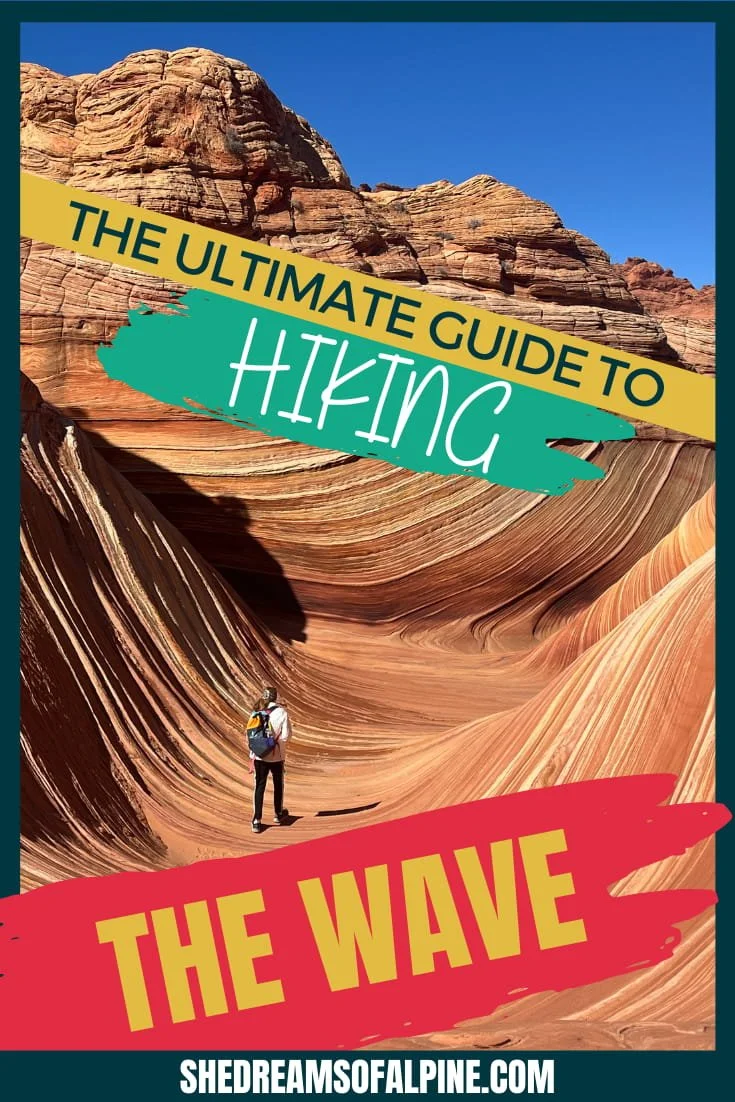


How to Get The Wave Permit - Understanding The Wave Lottery Process | The Wave is an iconic desert hiking destination that will blow your mind - if you can get a permit! This undulating sandstone formation is simply stunning, but getting The Wave permit is not a simple task. It took me several years to win The Wave permit lottery, and this guide to getting The Wave permits can help you make your Wave dreams come true, too! | shedreamsofalpine.com