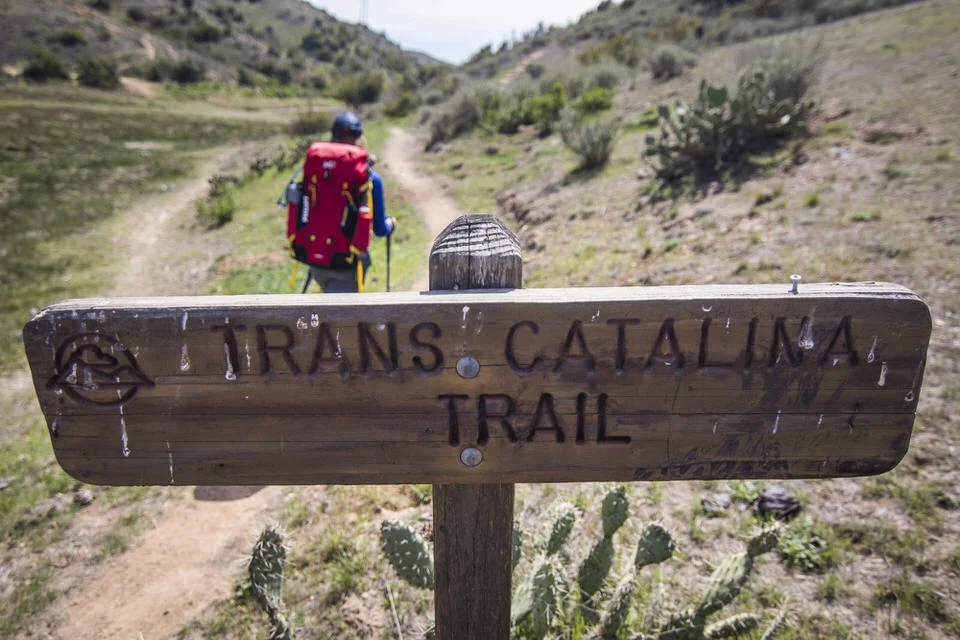
A Detailed Look at The Trans-Catalina Trail Map

Planning for your backpacking trip across Catalina Island can be intimidating at first glance. While there are a lot of options on the Trans-Catalina Trail Map for camping, you also aren't allowed to just camp anywhere that you want to. You need to have a plan for your trip. Add in the complication of getting to the island and needing to make advanced reservations, the whole process can get overwhelming. Trust me, I've been there. I actually had this backpacking trip on my list of places to hike for years before I actually pulled the trigger and learned what permits I needed in order to be able to hike here.
I pride myself in being a really organize person and I like to take complicated things and make them simple and less intimidating. So I hope this is helpful and helps give you the confidence to start planning your trip to Catalina Island to backpack the Trans-Catalina Trail.
If you want a full detailed guide to hiking the Trans-Catalina Trail, including details on best time of the year to go, how to get there, and permit details, I recommend checking out my Ultimate Guide to Backpacking the The Trans-Catalina Trail post. In this post we will go more in depth on the different ways you could break up this backpacking trip to fit the amount of time that you have and your physical fitness levels.

GRAB MY [FREE] OUTDOOR BACKPACKER STARTER KIT:
I created the Ultimate Outdoor Backpacker Starter Kit for you (and it's FREE)! This starter kit is filled with 14 pages of my best hiking and backpacking tips to help you learn what it takes to become a safe, confident, and self-sufficient outdoor backpacker!
Breaking Down the Trans-Catalina Trail Map:
There are several options for breaking up the Trans-Catalina trail, and we will go into detail later in this post on what the best option for you might be. But first, lets take a look at the Catalina hiking map to really dive into what the different "sections" of the trail are.
While it's not necessary to have a map while hiking this trail since the trail is very easy to follow, it's a useful tool if you want to see all the different side hikes you have the potential to do and understand where you can get water from while on the Island.
Here are some map options to help you plan your trip:
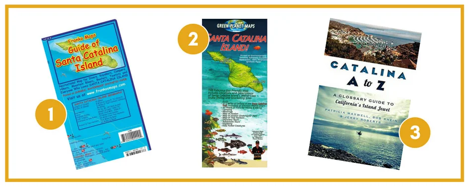
Santa Catalina Island California Adventure & Dive Guide - This is a cool map that has a lot of extra detail that you won't find on the standard maps you can buy on the island. It has details about key points of interest and all the different kinds of ocean life that can be found in the waters around Catalina Island.
Santa Catalina Island - Another map option of the island you can find online
Catalina A to Z:: A Glossary Guide to California's Island Jewel - And if you're itching to know more than just the map info, you can check out this Catalina guide!
You can also wait and buy a map of the island when you arrive. Just go to the Catalina Island Conservancy Office in Avalon.
You could use the free downloadable map online here as well!
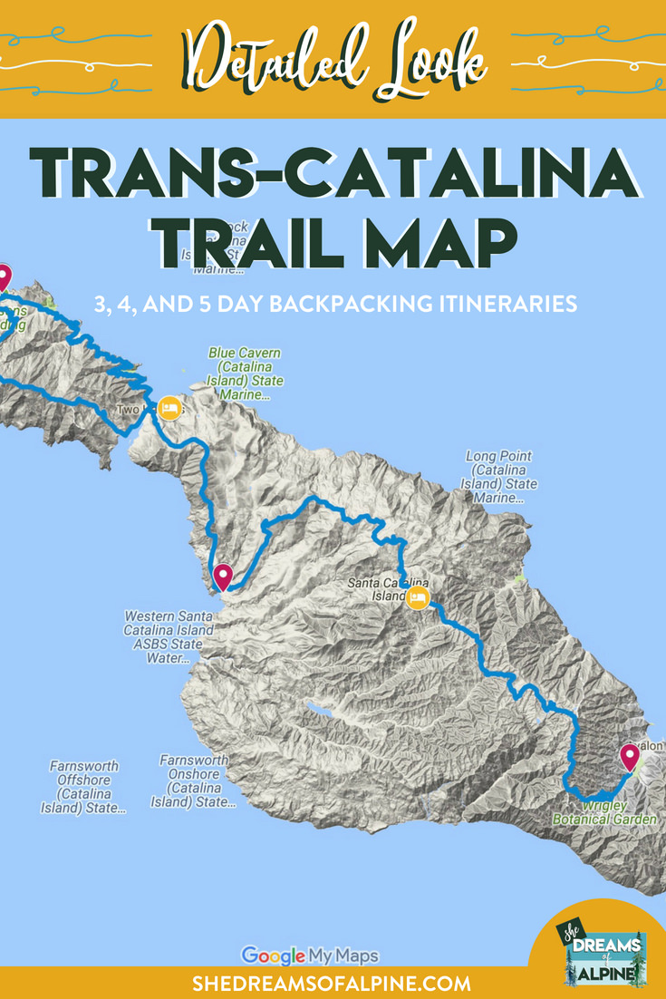
OR You can click through the map I made on google maps (below), which has our GPX file from when we did the hike.
Click on the Map below in order to be taken to an interactive google maps.

DOWNLOAD THE GPX FILE FOR THIS TRAIL!
Knowledge is power my friend, and I'm a girl who loves data. Get access to this trails GPX file PLUS my library of GPX files with tracks and waypoints for all the trails loaded onto the She Dreams of Alpine blog.
Load this puppy into your trusted GPS and rest easy knowing you have tracks to follow on your next hike or backpacking trip.
DON’T HAVE A GPS? YOU SHOULD.
Look, I believe every hiker and backpacker should be self-sufficient, and that includes knowing how to practice smart navigational skills in the outdoors. This is something I teach in my backpacking program, but I want to give you a couple GPS options to get started. Don’t ever risk getting lost, and don’t rely on other people for your safety. Be empowered, take 100% ownership for yourself my friend. Here’s what I recommend:
1) GAIA GPS Phone App: At a bare minimum, consider getting a premium subscription to GAIA GPS App. This App allows you to download maps in advance and take them offline into the backcountry. You can record your tracks, upload tracks from online to follow (like the one I have above), and so much more with this phone app, and GAIA is offering a special discount to those who subscribe online through my link above, 20% off their normal prices. But even if you don’t use my link... please, at a minimum get a GPS phone app to help you navigate outdoors!
2) Handheld GPS: If you hike often or go backpacking, then I highly recommend you investing in a handheld GPS. I own a Garmin 64st and LOVE this device.
3) Handheld GPS with Satellite Communicator: However, if you have a little bit more money to spend, if I were starting over, I’d get the Garmin inReach Explorer+ which provides not only GPS tracking capabilities, but also an SOS satellite search and rescue communicator. I own the Garmin inReach mini now and I pair it with my Garmin 64st, but you can save weight by getting this all-in-one solution.
Ok, onto the good stuff. What you came here for!
Like with most trails, there are many ways you could break up this hike, however due to the fact that you can't just camp "anywhere" I am going to give you what seems to be, in my opinion, the most obvious sections of breaking up the trail.
For the below descriptions I assume the following:
You are backpacking the "official" portion of the Trans-Catalina Trail hike. This doesn't include Starlight beach, however, I'll mention some "bonus" notes on that section of the trail too if you decide to add that onto your trip. The official trail is roughly 38.7 miles long. If you go all the way out to Starlight beach, you will add on roughly 7 more miles to your trip, depending on how you tackle it, leaving a grand total of 45.7 miles. If you were really ambitions you could try adding on even more additional Catalina hiking trails to your trip, but the Trans-Catalina Trail will be a big challenge in and of it itself.
You start your hike in Avalon
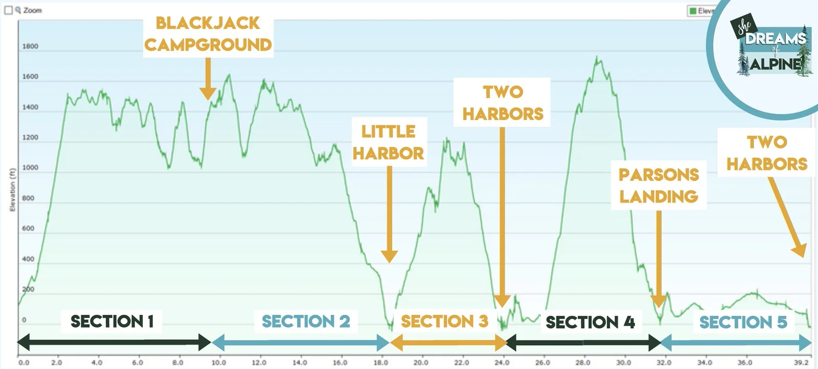
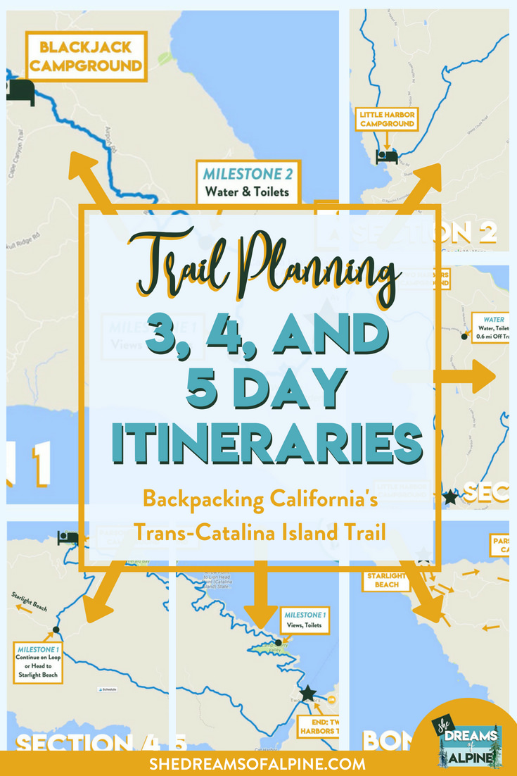
SECTION 1: Avalon to Black Jack Campground
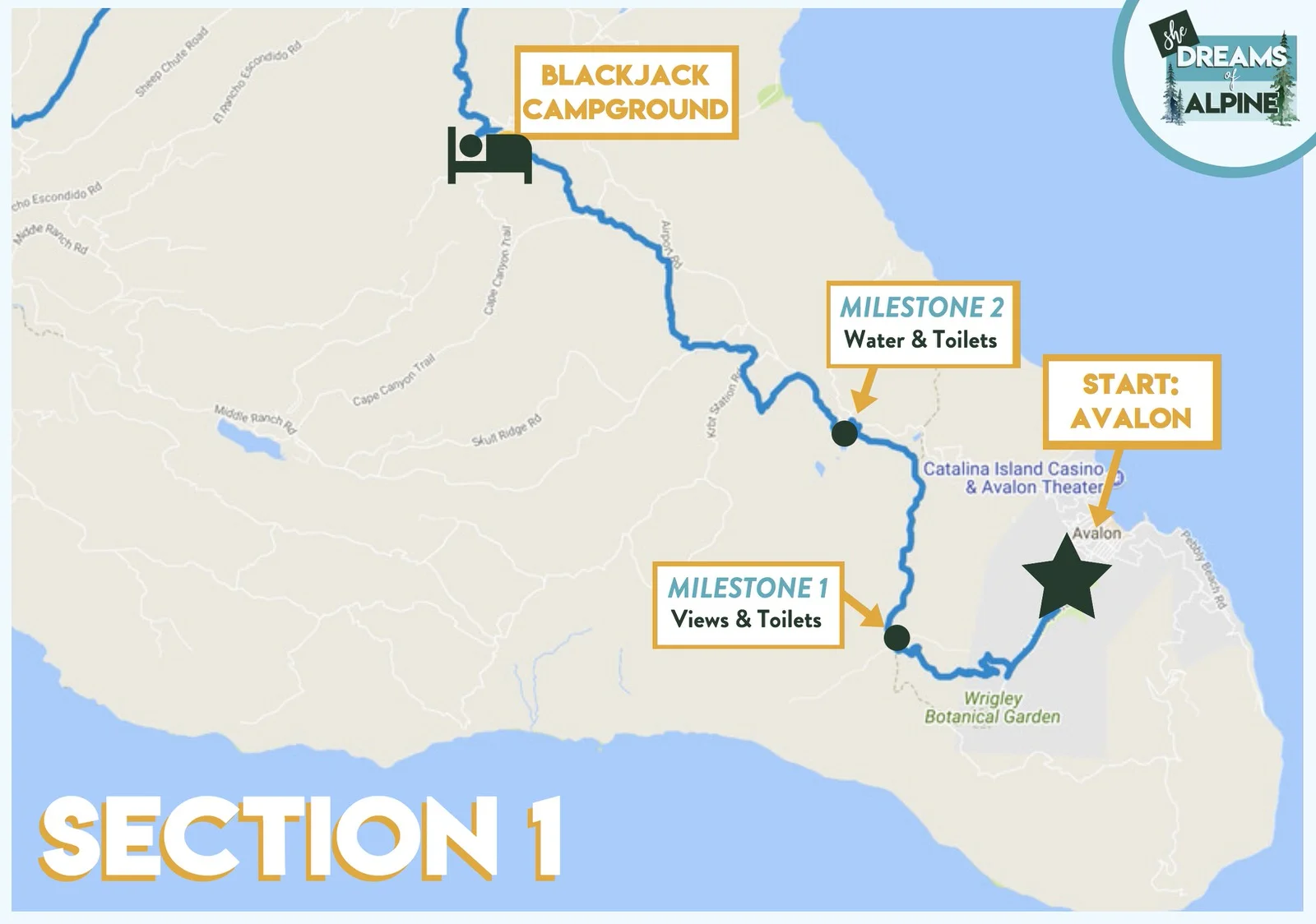
Start: You'll start your hike on the Trans-Catalina Trail Map at Avalon. If you wanted to stay the night here there are plenty of hotels to stay at, or you could camp night zero at Hermit Gulch Campground. Make your way to the Catalina Island Conservancy in town to pick up a map and check in for your hike before getting started.
Milestone 1: You'll reach this first milestone at the top of a 1,500 ft elevation gain uphill, about 3 miles in. There are bathrooms and a great viewpoint at the top as well. Also a side trail that goes to the "Lone Tree" which you can see off in the distance is close by. After this milestone, the biggest portion of your uphill is complete for this section of the trail.
Milestone 2: Haypress Recreation Area is another good place to take a pit stop and fill up with fresh water and use the restrooms! This will be your last chance to fill up your water until you reach Black Jack Campground
Camp: Online this campground is called "primitive" but you'll feel very comfortable here, with nice backcountry toilets, fresh water, "bison" boxes (similar to bear boxes where you can store your food at night), picinic tables, and fire rings. Fill up on water here before you start your next section of the trail.
SECTION 2: Black Jack Campground to Little Harbor Campground
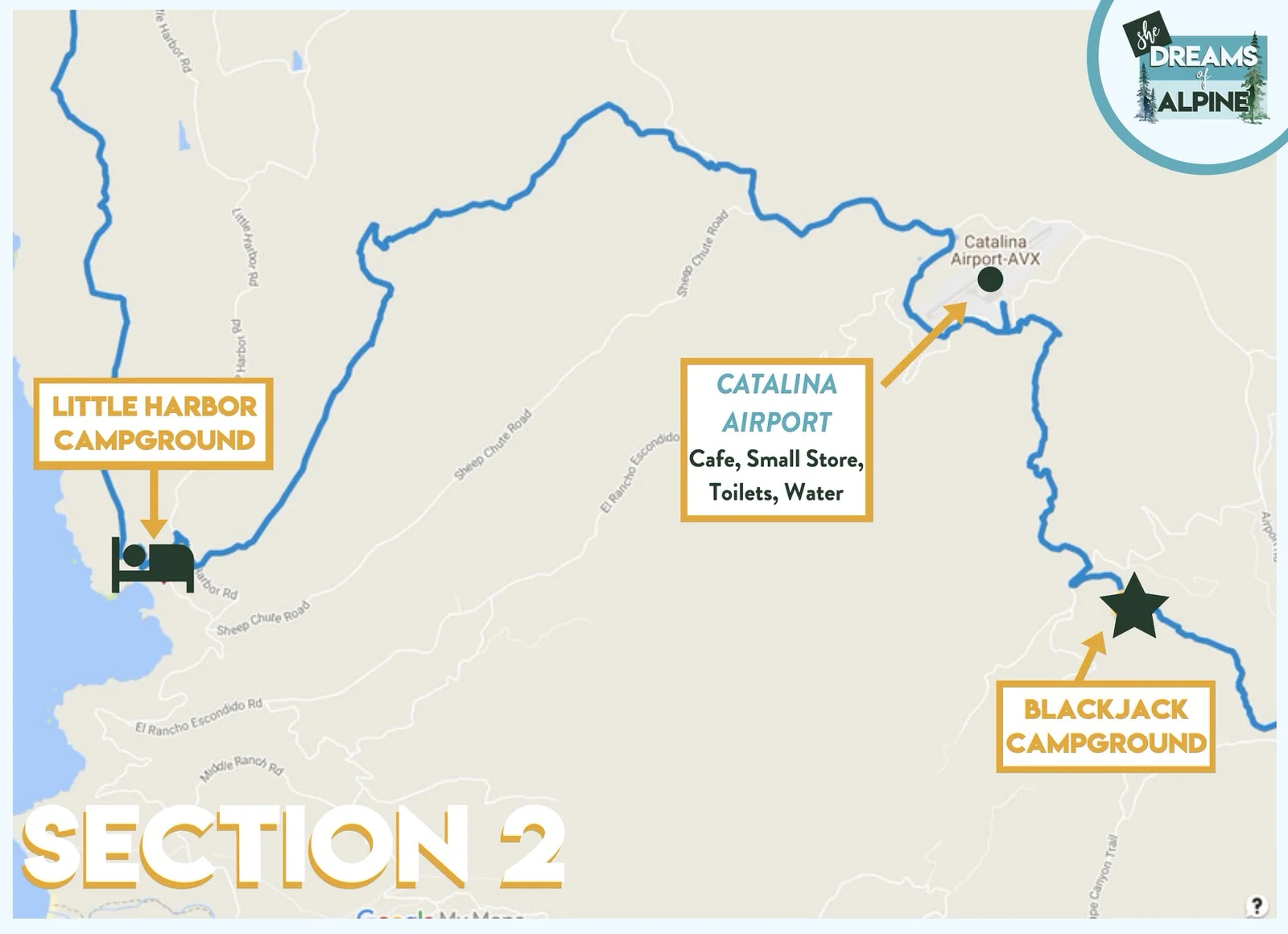
Start: For section two you'll start your day off in Black Jack Campground. You won't have any "huge" elevation gains in this section, but there will be a lot of up and down.
Catalina Airport: The first noteworthy place you'll reach on your hike is the "Airport in the Sky", the Catalina Island airport. There is a small cafe here and a small store, so if you wanted to you could grab breakfast, snacks, or coffee and take time to relax. There are also really nice bathrooms here, so it's worth a stop if you have time.
Camp: You'll end your day camping at Little Harbor Campground, an adorable campground that is right on the beach!
SECTION 3: Little Harbor Campground to Two Harbors Campground

Start: Right off the bat from the Little Harbor Campground you will head uphill about 1,300 feet. Make sure to fill up on water at the campground this day because there aren't any convenient stops for water on this section of the trail. You'll get to hike closer to the coastline during this section, so be sure to enjoy the views.
Camp: When you get into the town of Two Harbors, the Two Harbors Campground is a little less than a mile to the South of town. It has great views of the ocean, and if the day is clear enough you might be able to see the mainland of California. Depending on how much you're up to "roughing it" or not, you can either spend your night at the campground or head into town for food at the restaurants and bars there! While not as busy as Avalon, there is still a ton to do at Two Harbors. You'll end up back here in Two Harbors at the end of you backpacking trip as well.
SECTION 4: Two Harbors Campground to Parson's Landing Campground
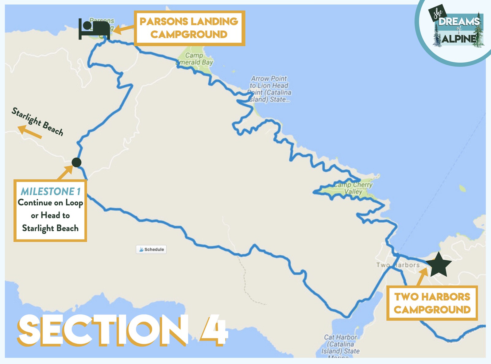
Start: You'll head toward Cat Harbor to find the trail again as you start section 4 of the hike. According to Trans-Catalina Trail Map on the official website, there is no more fresh running water stops until you make your way back to Two Harbors. SO MAKE SURE TO TAKE PLENTY OF WATER! Especially if you are going all the way out to Starlight Beach! I will note however, according to the details on Parson's landing Campground, if you end up staying at this campground you are required to purchase at least one locker key. Each locker key contains 2.5 gallons of water and a bundle of firewood. So plan accordingly.
Milestone 1: This is where you either take the path (called Fenceline Road) to Parson's Landing Campground, or you continue on to Starlight beach. In this section though, we assume you head toward Parson's Landing. There are some very steep descent sections on this part of the trail, come prepared and BRING HIKING POLES! You won't regret it.
Camp: Parson's Landing is a beautiful secluded primitive campsite. You'll feel like you have the island to yourself (and the other campers) when you are here. I wish we had stayed here on our visit, but we hiked the trail in 3 days and so we didn't end up camping here.
SECTION 5: Parson's Landing Campground to Two Harbors Campground

Start: This last section won't have much elevation gain or descent, and your hike will be hugging the coastline for the rest of the way back to Two Harbors. If you have a ferry out of Two Harbors this same day, be sure to leave your campsite early enough to make the ferry in town. Typically Ferry's from Two Harbor leave early afternoon.
Milestone 1: When you reach Lion's Head there are some toilets and great views! You are also almost done with the trail!
End Hike: While you are waiting for your ferry, treat yourself to some good food and beers in town!
BONUS SECTION: Starlight Beach Details

If you decide to hike out to Starlight Beach, keep going straight instead of turning on Fenceline Road out to Parsons landing. You will essentially just extend your loop to the other end of Catalina Island.
If you go all the way out to Starlight beach, you will add on roughly 7 more miles to your trip
There is NO CAMPING at Starlight Beach, so plan for a longer day because you will need to make it to Parson's Landing for your next campground.
Trans-Catalina Trail Elevation Gain
Based on the sections detailed above, here is what the elevation gain looks like for each of the sections, excluding Starlight Beach.
GRAB MY [FREE] FULL BACKPACKING PACKING CHECKLIST!
Want a full list of everything I recommend to take backpacking with you? Download our free backpacking packing checklist below! This download also includes my layering tip-sheet PLUS 25+ backpacking food ideas.

Itinerary options - Trans-Catalina Trail Map

Our group decided to hike this trail in three days, but you can easily adapt this for 4 or 5 days. In the Itineraries below I assume you will only hike out to Parsons landing (the official trail) and not out to Starlight Beach.
3-DAY ITINERARY - Aggressive Itinerary
Be prepared for longer mileage and elevation gain if you decide to tackle this in 3 days. It is totally doable, but I would say only do this if you know you are capable of this sort of mileage. The elevation gain on the Trans-Catalina Trail is nothing to sneeze at.
Day 1 – Section 1, About 10.7 miles from Avalon to Black Jack Campground
Day 2 – Section 2 + Section 3, About 14 miles from Black Jack Campground to Two Harbors Campground
Day 3 – Section 4 + Section 5, About 14 miles from Two Harbors Campground - out to Parsons Landing - back to Two Harbors Campground
4-DAY ITINERARY - Moderate Itinerary
Day 1 - Section 1, About 10.7 miles from Avalon to Black Jack Campground
Day 2 - Section 2, About 8.5 miles from Black Jack Campground to Little Harbor Campground
Day 3 - Section 3, About 5.5 miles from Little Harbor Campground to Two Harbors Campground
Day 4 - Section 4 + Section 5, About 14 miles from Two Harbors Campground - out to Parsons Landing - back to Two Harbors Campground
5-DAY ITINERARY - Relaxed Itinerary
Day 1 - Section 1, About 10.7 miles from Avalon to Black Jack Campground
Day 2 - Section 2, About 8.5 miles from Black Jack Campground to Little Harbor Campground
Day 3 - Section 3, About 5.5 miles from Little Harbor Campground to Two Harbors Campground
Day 4 - Section 4, About 6.5 miles from Two Harbors Campground to Parsons Landing Campground
Day 5 - Section 5, About 7.5 miles from Parsons Landing Campground to Two Harbors Campground
Remember: The official trail is roughly 38.7 miles long. If you go all the way out to Starlight beach (which you will have to add on to your hike from Two Harbors to Parson's Landing) you will add on roughly 7 more miles to your trip, depending on how you tackle it, leaving a grand total of roughly 45.7 miles.
Again, don't forget to check out our Full Guide to Backpacking the Trans-Catalina Trail for even more great details and resources + lots of great photos of the trail!

Cheers,
Allison - She Dreams of Alpine


related posts:


Travel Alone – 57 Quotes to Inspire Your Solo Travels | There’s something magical about traveling alone or going on solo adventures. Traveling alone forces us to grow and test what we are really made of and maybe even go through a transformation of self-discovery. These 57 travel alone quotes celebrate the beauty in going solo. | shedreamsofalpine.com