Santa Clarita Half Day - Towsley Canyon Loop Trail 2 Ways (Hike or Mountain Bike)

As we begin to transition into the winter season here in California, I was searching my brain for good "between-season" weekend or day trips that we have gone on recently. Contrary to popular belief (at least with my family), I'm not always outside exploring. I wish I could be, but life is never perfect (big sigh, but what is perfect anyways?). The past month and a half I have been traveling every weekend, which just drains me since we have so many new projects going on + a full time job. On top of that, not all those traveling weekends were outdoors, and since I am really excited about "Bishop Climbing Season" (ha!) I have been spending quite a bit of time out there too, but I'm sure my readers can only handle so many "This is why Bishop California is Awesome" posts.. or maybe I'm wrong? I certainly know I could subscribe to a blog about Bishop Climbing! However, sometimes it's nice not to travel every weekend. For weekends like that, we tend to go on "day trips" which usually includes anything within a 1-2 hour driving range.
Towsley Canyon Loop Trail is one of those half-day, day-trip activities. Michael and I have been up there a few times because we like to go to Santa Clarita since it's so close. So if you are within a 1-2 hour driving range of Santa Clarita, consider going on this lovely little hike/bike ride. You can even make a nice day of it afterwards spending some time in Santa Clarita.
Here's how we usually enjoy spending our "half-day":
A morning hike or mountain bike ride at Towsley Canyon Loop Trail
Grab some lunch (usually a poke bowl or sushi burrito), Temakitto is one of our favorites
Finish with a 2-3 hour climbing session at the Top Out Climbing Gym, because it's just so much nicer than our local climbing gym
I apologize in advance, because my photos aren't the best for the area, and I usually like this blog to stand out with our photos. Whenever we go back to this trail, I'll try to re-vamp this post with some better quality photos. Until then, thought this would be a good mid-season, day trip activity for those of you in the SoCal area.
High Level Trip Details:
~5.3 Miles Round Trip (trail is a loop)
~1,770 feet total elevation gain (other sites will say anywhere from 1,000'-1500', my stats are just based on the phone GPS I was using at the time, which is potentially questionable, not my favorite GPS to use. I'll have to re-measure it with my garmin GPS sometime)
Trailhead elevation (1,354 feet)
Highest Point on the trail (2,466 feet)
Bring plenty of water for about a 2-3 hour hike or ride depending on your fitness level
Biker and Hiker and Dog Friendly!
When to Go:
Trail can be good year-round, but the summers will be warm, so go during the morning or evenings!
How To Get There:
Easy to find on google maps, type in Towsley Canyon Trail, you can see in google maps here
There is free and paid parking at Ed Davis Park in Towsley Canyon, so if you are traveling up here on a busy weekend, try to get there early to avoid paying for the parking. The paid parking is $7 I believe.
Below is a snapshot from my phone GPS with a few of the stats that I mentioned above.
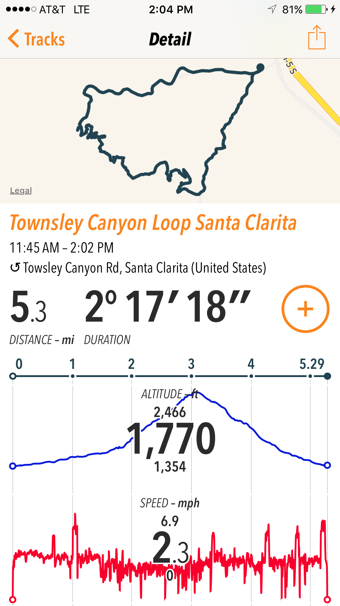
Trail Details
I have no fucking idea what's going on in the photos below, but apparently Michael was wearing a glove on his foot? I think he forgot his socks? Anyways, funny regardless, and this is the parking lot for Towsley Canyon Park. We usually get here early and don't have an issue grabbing a spot in the free parking area.
Like I said above, you can hike, run, meander, hang out with your pup, or mountain bike this trail. We've hiked and biked the trail.
You'll see the hike noted as "difficult" or "hard" on other sites, and I suppose that is fair since you climb around 1,700 feet in 2.5 miles. However, since it was so short, relatively speaking, we find that it's a pleasant "calorie burning" 2 hour hike or ride.
Mountain biking the ride was a bit more challenging for me simply because I am just not in the best mountain biking shape. On the steepest parts of the trail I had to walk my bike a bit, but other than that I found the trail to be fairly good for a beginner-intermediate level mountain biker. Of course, walk whatever downhill parts you don't feel comfortable with, and be aware of sandy patches on the downhill because the area can be dry in parts. Use good judgement. If you are brand new to mountain biking, maybe get some experience on easier trails before riding this one due to its steepness.


I've only ever hiked/biked the Towsley Canyon Loop counter-clockwise, but you could go either way. If you are going counter-clockwise, continue up Towsley Canyon Road toward a ranger station and lodge. You'll be hiking on pavement a bit before you get to a dirt trail. You will eventually pass the ranger station and some other buildings. Continue to stay on the trail and stay left when there is a fork to the path. Hike towards the sign labeled "Towsley View Loop Trail" (this is sometimes chained off, but that's ok, hike around the chains). If you stay on the most worn down part of the trail, you will be in good shape.
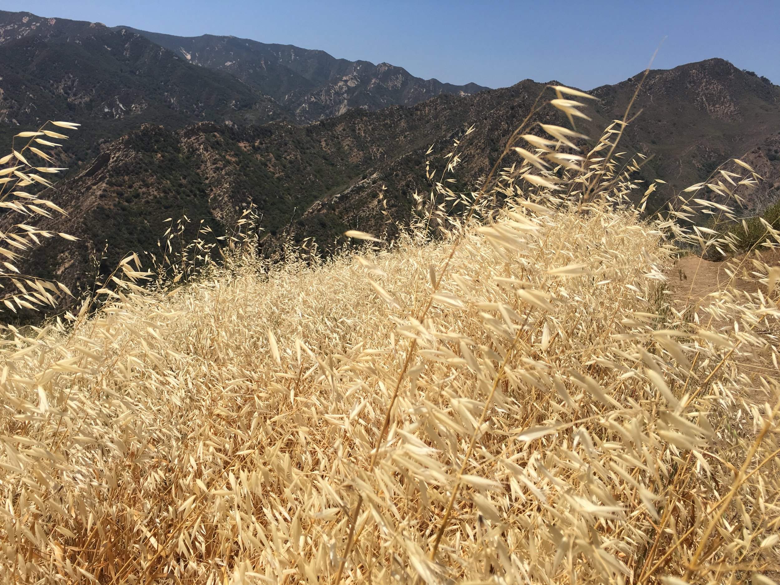
You'll eventually end up hiking through some beautiful narrow canyons. This was one of my favorite sections of the trails!

You'll cross some streams and if you're hiking in the spring you will see some beautiful and interesting flowers.
Eventually (around 1.75 miles) you will come out of the canyon and continue hiking up a steeper trail. Small tar pits can be seen on the side of the trail, so keep an eye out for them!


It will get steeper and steeper as you make your way to the peak of the loop. This is where I found it a bit difficult to keep my stamina going on the mountain bike. There were a few times I had to get off the bike and hike with it just to catch my breath.

When you reach the peak of the loop you'll be rewarded with great views of the Santa Clarita area!


and the beautiful Santa Susana Mountains!

Going counter-clockwise on this trail is a little less steep on the uphill and steeper on the downhill. Going clockwise, you'll encounter a steeper uphill and more gradual downhill. Mostly though, they are pretty comparable, so just pick your poison.
On your way down you'll come up to a 3-way junction (around mile 4), but just keep left in order to loop back to the trailhead, and at the very end keep right at another fork to head to the parking area.
It sounds confusing but most of the trail splits just lead to more viewing points or connect back with the main trail, and it's not as complicated as it may sound.

We always feel properly worked by the end of the trail and deserving of a sushi burrito! Those are the best kind of days in my opinion, when you feel guilt free about your next carb-intensive meal. Bring on the white rice!
Great little day hike or ride. Views all around, challenging, beautiful canyons, tar pits, what more could you want in a day hike? Really hope you get a chance to enjoy it.
Cheers my friends.