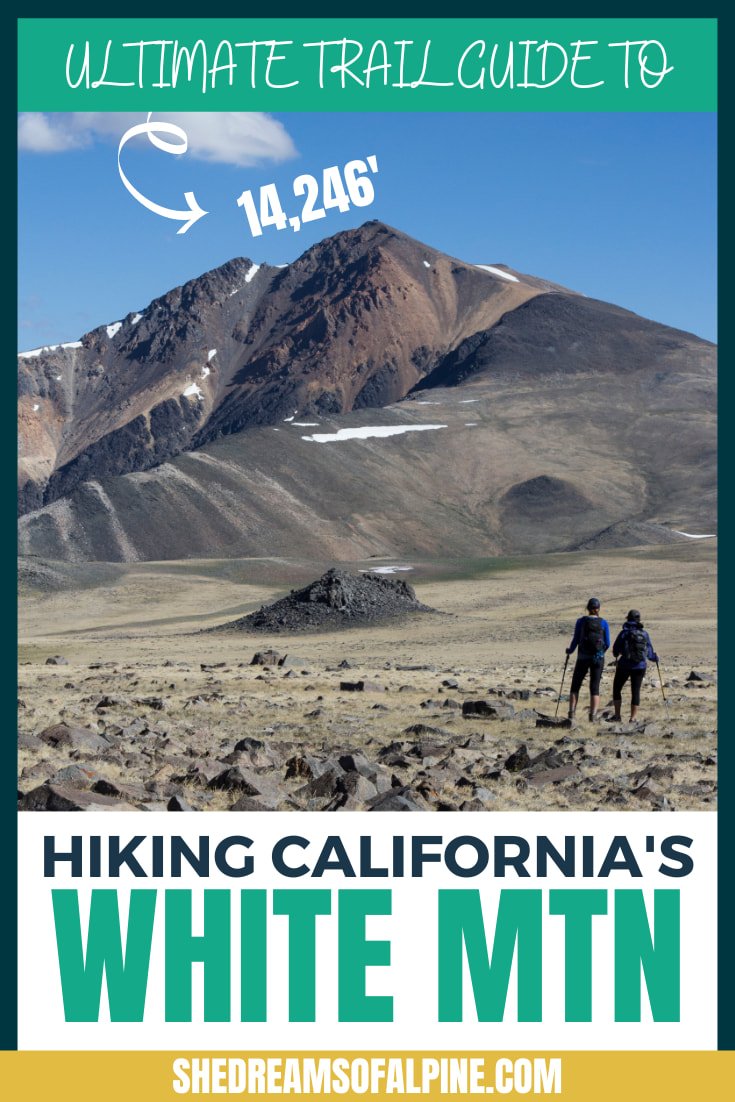
White Mountain Peak Hike - California 14er 2024 Trail Guide

Even though the White Mountain Peak hike is often referred to as California’s “easiest” peak over 14,000 feet to hike, it is still a challenging and worthwhile summit to achieve and is a great introduction to hiking 14ers.
While hiking White Mountain Peak, you will have to battle its over 3,400 feet of elevation gain in 15 miles all while adapting to the altitude of its high summit. So whether you are ready to dip your toes into hiking 14,000 foot peaks or you are just looking for a great day hike in California, be sure to put White Mountain Peak on your peak bagging list!
If you are working your way towards harder 14er mountains, White Mountain Peak is a great beginner California 14er!
While not my favorite California 14er, White Mountain Peak was definitely the easiest of all the ones I have done to date. We were able to hike the peak in just a half-day since the trailhead starts at around 12,000' and gains only about 3,400 feet of total elevation gain to the summit.
Some people like to have a bit of fun with this peak since the trail to the summit is practically a 4WD road the whole way up. It is not uncommon to find trail runners and even mountain bikers sharing the trail with you on your hike.
GRAB MY [FREE] OUTDOOR BACKPACKER STARTER KIT
I created the Ultimate Outdoor Backpacker Starter Kit for you (and it's FREE)! This starter kit is filled with 14 pages of my best hiking and backpacking tips to help you learn what it takes to become a safe, confident, and self-sufficient outdoor backpacker!
WHAT WE WILL COVER IN THIS WHITE MOUNTAIN TRAIL GUIDE
The White Mountain trail guide below goes into great detail on everything you need to know logistically about hiking White Mountain Peak. Plus, I’ve included some fun photos and a trip report of our hike on the White Mountain trail.
In this post, we will cover the following topics to help you plan and prepare for your very own successful White Mountain Peak hiking adventure:
White Mountain Peak Hike Stats - All the nitty-gritty details for the trail in one spot. How many miles, elevation gain, & more.
Best Time to Hike White Mountain Peak – Details about the best time to hike White Mountain and typical White Mountain Peak weather to expect on your trip.
White Mountain Peak Trail Map & GPX Files - I've created a map detailing the whole trail that you can explore, including a look at the elevation gain/profile of the hike. You can also download this file as a GPX file to upload into your own personal GPS device.
How to Get to the White Mountain Peak Trailhead – Driving and parking recommendations to get to the White Mountain Trailhead.
White Mountain Camping – Where to camp when visiting White Mountain Peak, California.
Important White Mountain Peak Safety Tips – Tips about the top hazards to expect along the trail.
What to Bring on Your White Mountain Hike – The essential packing list for the hike. Don’t hit the trail without these things!
Turn-by-Turn Trip Report of the White Mountain Peak Hike
If you’re looking for something specific, feel free to skip ahead to the section you’re looking for!
Plus, check out the bottom of this post to find more California hiking trail guides in the Sierra Nevada and other additional hiking, camping, and backpacking resources!
>> Also, be sure to take a look at my post on 7 crucial tips to hiking and summiting a 14er, especially if this is your first 14,000-foot peak hike.
1. WHITE MOUNTAIN PEAK TRAIL STATS
White Mountain Peak is part of the Inyo California White Mountain Range and is the 3rd tallest mountain in California and the tallest peak outside of the Sierra Nevada mountain range. In fact, there are only two California 14ers that lie outside of the Sierra Nevada Mountain Range – White Mountain and Mount Shasta.
The White Mountain range rises out of the desert, and from its peaks looking west, you can see the Sierra Nevada Range in all of its beautiful glory, and to the east the hot desert of Nevada.
The California White Mountains are home to ancient bristlecone trees (the oldest living trees on earth), desert bighorn sheep, pronghorn antelope, and a lot of hungry marmots! In fact, on your drive up to the White Mountain trailhead, you could even take a side trip to visit the ancient bristlecone forest.

WHITE MOUNTAIN PEAK HIKE QUICK FACTS
California's White Mountain Peak Elevation: 14,246 feet
Best Trail to Summit: Most people hike the Class 1 South Face route which is essentially a 4WD road that goes practically all the way to the summit.
Type of Trail: Out and Back
Mileage: ~15 miles round trip
Total Elevation Gain of White Mountain Peak: ~3,400 feet total elevation gain
White Mountain Trailhead: Barcroft Gate on White Mountain Rd.
Trailhead Elevation: 12,000 feet
How long does it take to hike White Mountain Peak? 7-9 hours as a day hike
Difficulty: Moderate-Difficult (mostly because of the high altitude)
Permit Required: No! There is no permit needed for a day hike up White Mountain Peak! If you camp at trailhead and want a campfire, you will just need to fill out a campfire permit.
Water Available? There is no water along trail, so bring plenty of water for a full day of hiking.
Dog Friendly? I've read that this trail is dog friendly as long as your pooch is leashed, but I didn't see any dogs when we did the hike.
2. WHITE MOUNTAIN PEAK WEATHER – BEST TIME TO HIKE
September is my favorite time of the year to backpack or hike peaks in the Sierra Nevada area and White Mountain is just across the way from the Sierras so it has similar temperature profiles. The weather is perfect and there are fewer mosquitos (which can be really bad when it is warm). But be aware that September is now wildfire season, so fires could affect your hiking plans.
You could also plan to go in July and August, but expect the weather to be a bit warmer (with a chance of relentless mosquitos).
June and October are hit or miss in the Inyo-White Mountain Range. If there was a big snow year in California, there may be too much snow on the trail in June. Alternatively, in October, the mountains can start to get their first snowfalls of the season.
Check out the White Mountain Peak weather average temperature map below for reference.

Be prepared before you go. Just like I teach my students in my backpacking program. It’s important that you research your weather conditions before you go, weeks, and days before your trip. You can check the weather conditions here:
Mountain Forecast – One of my favorite sources for mountain weather forecasts when checking a few days before a trip
Also, be sure to call the ranger station before heading out on weather and snow updates.
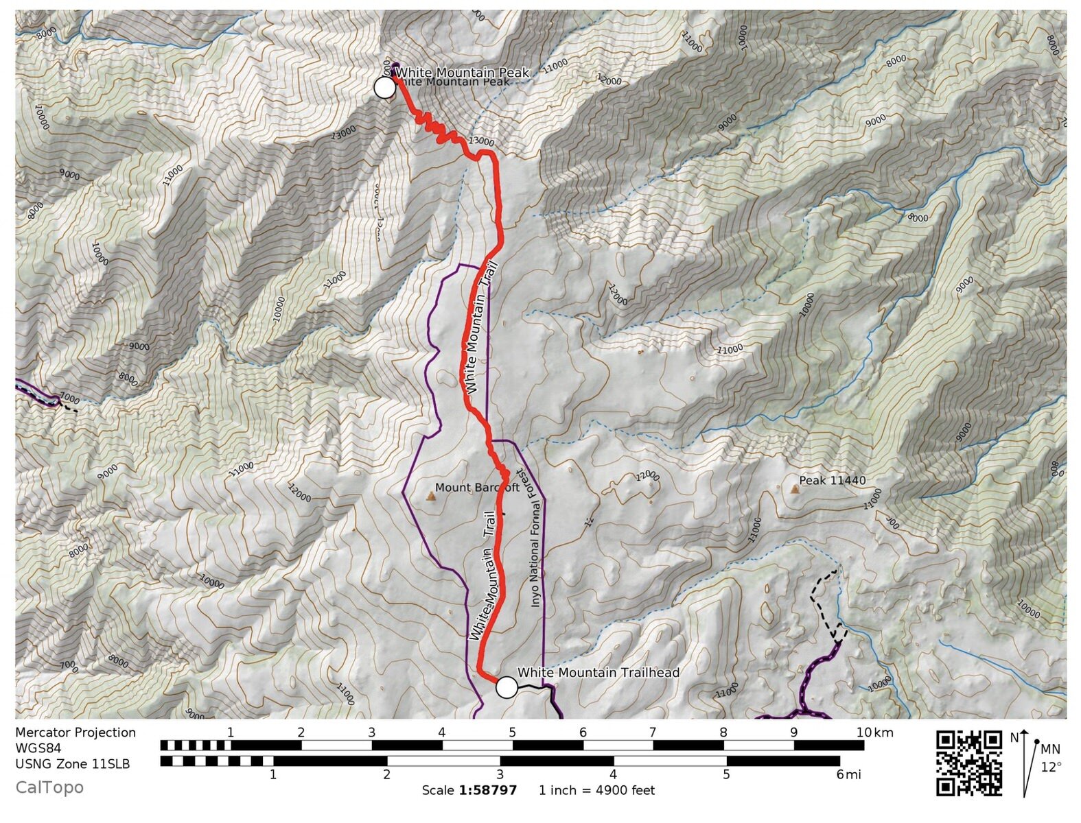
3. WHITE MOUNTAIN PEAK TRAIL MAP & GPX FILES
The easiest trail to the summit is the Class 1 South face trail that starts at Barcroft Gate on White Mountain Peak Road. It is essentially an easy, wide 4WD road that goes practically all the way to the summit, though the final bit of hiking will be include steep, narrower switchbacks to the final summit.
This area was originally developed as a research area and is still used that way to this day. While you are not allowed to drive up the road, you may see some vehicles and those people are likely researchers on the mountain.
It really isn't necessary to have a GPX file pre-loaded to your GPS on this hike like some trails in the Sierra Nevada (like Split Mountain Peak), but if you're like me and just love data, I've included it below!
Below is a map of the White Mountain Peak hiking trail.
DOWNLOAD THIS WHITE MOUNTAIN PEAK GPX FILE
Knowledge is power my friend, and I'm a girl who loves data. Get access to this trails GPX file PLUS my library of GPX files with tracks and waypoints for all the trails loaded onto the She Dreams of Alpine blog.
Load this puppy into your trusted GPS and rest easy knowing you have tracks to follow on your next hike or backpacking trip.
WHITE MOUNTAIN PEAK HIKE ELEVATION PROFILE
Below you can see the elevation profile for California’s White Mountain Peak hike:

DON’T HAVE A GPS? YOU SHOULD.
I believe every hiker and backpacker should strive to be self-sufficient, and that includes knowing how to practice smart navigational skills in the outdoors.
This is an important safety skill set that I teach in-depth inside of my backpacking program. There’s no reason to risk getting lost in the outdoors.
Here’s what I recommend to get started:
(Note: this list contains affiliate links)
Don’t know where to start? If you need help with some Gaia GPS basics, download my quick Gaia GPS navigation 101 guide.
My Go-To Trail Setup: The Gaia GPS app (premium subscription) + the Garmin inReach Mini.
Learn more about the best GPS devices for hiking here.
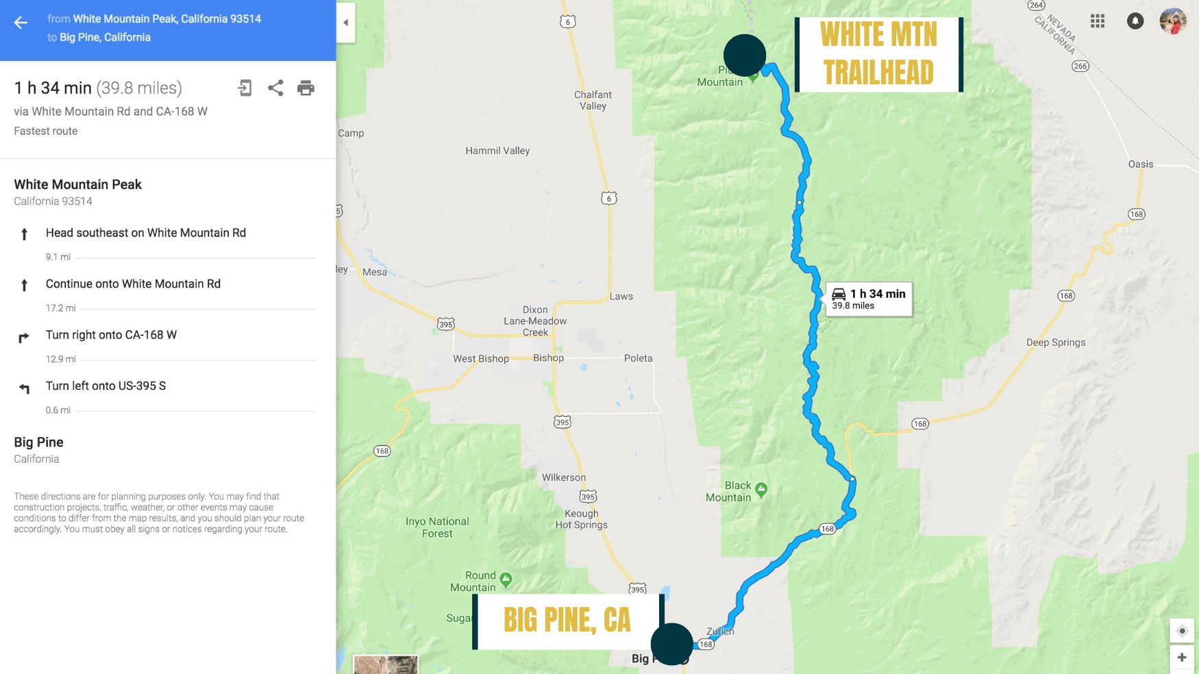
4. HOW TO GET TO THE WHITE MOUNTAIN PEAK TRAILHEAD
Getting to White Mountain Trailhead is fairly straightforward. We simply typed “White Mountain Peak California” into Google Maps, and it got us to the trailhead without a hitch.
The way to go is to take US-395 to Big Pine, turn east onto CA-168 toward the White Mountains and Ancient Bristlecone Pine Forest. After 13 miles, turn left onto White Mountain Road. The pavement ends just after Schulman Grove and then turns into a 4WD road for the remaining 17 miles until you reach the Trailhead at Barcroft Gate.
OFF-ROAD WARNING: There are 17 miles worth of "4WD road" that you will be driving on to get to the trailhead. Plan for about an hour to an hour and a half of driving once you get to the dirt road.
>> See Section 6 On Important White Mountain Safety Tips for More Information About How to Avoid Flat Tires on Your Drive Up to White Mountain Peak
5. WHITE MOUNTAIN CAMPING
You may want to camp the night before or after your hike up White Mountain Peak, either to help yourself acclimatize before heading up to 14,000 feet or to just get an early start on the trail. Either way, there are several good options in the area.
CAMPING NEAR THE TRAILHEAD (PRE-HIKE)
Many people opt to camp at the trailhead. We considered doing this but decided against it because since we were coming up from sea level, we wanted to let our bodies slowly adapt (as best we could) to the change in elevation.
If you camp at the trailhead and want a campfire, you will just need to fill out a campfire permit. The camping here is free is on a first-come, first-serve basis.

OTHER CAMPING OPTIONS NEAR WHITE MOUNTAIN
There are many campgrounds along the way up Highway 395, or you could stop at Alabama Hills in Lone Pine and do some free camping there. We didn't choose this either because it was a bit further from the trailhead and we wanted an early start, but also it is at a lower elevation.
Camping at Grandview Campground is another option. This campground is about 20 miles from the trailhead. The Grandview Campground is at 8,500 feet of elevation so it was perfect for helping us adapt to the elevation change we were experiencing before going up to 12,000 feet at the trailhead.
The campground doesn't take reservations, but we didn't have any issues finding a site to sleep at on Friday night. Sites are $5/night. This seemed like our best option since we were driving up late Friday night and we didn't want to drive the 4WD portion of the trail in the dark.
I highly recommend spending the night at slightly higher altitude the night before your White Mountain Peak hike in order to minimize altitude sickness effects.
6. IMPORTANT WHITE MOUNTAIN PEAK SAFETY TIPS
While White Mountain Peak is technically the easiest California fourteener hike, there are still some challenges to it that you need to consider.
ALTITUDE SICKNESS
One key thing to take into consideration when hiking White Mountain Peak is the altitude. If you’re not used to hiking at altitude, it is super important to prepare for how it will affect you and learn how to properly acclimate.
Altitude sickness is extremely serious, and you should be prepared to turn around and descend if you or anyone in your hiking party starts showing symptoms of Acute Mountain Sickness (AMS). The main symptoms include persistent headache, difficulty sleeping, dizziness, fatigue, loss of appetite, and nausea or vomiting.
If you notice these symptoms, you should descend immediately (no matter how close you are to the summit), because continuing up will only make things worse. AMS can also affect your own thinking, so it’s important to look out for each member of your group and watch for the symptoms or other unusual behavior.
Altitude sickness is the biggest reason people fail to summit White Mountain Peak. The trailhead starts at 12,000 feet which is high! Definitely consider camping at a lower altitude (~7,000 to 8,000 feet) a day or two before your hike.
FLAT TIRES
Another big reason people fail to summit White Mountain Peak CA, is because they get flat tires on their way to the trailhead – seriously!
When we went, the 4WD road wasn't too high clearance, but the rocks on the road were small and sharp. We made it just fine to the trailhead on our way in, but ended up getting a flat tire only about a mile out on the way back (what luck!).
Here are some driving tips, based on our personal experience getting to White Mountain trailhead, for the off-road portion of this road:
Drive slowly!
Make sure your car has a spare tire, and you know how to change it
Bring a "fix-a-flat" can as a backup to your spare tire
Put extra water and supplies in your car in case something happens and you are unable to get your flat fixed
If possible, take a vehicle with good tread and tires

MARMOTS
Although I have never personally experienced any issues with marmots at the White Mountain Trailhead, there are a lot of reports online that say that they can be a big problem.
The marmots are known to chew through car wire and hoses that are exposed underneath the car, leaving people potentially stranded at the trailhead and needing a really expensive tow.
Apparently they enjoy the anti-freeze and can consume it without dying. According to the National Parks Service, the marmots are the worst from early spring to mid-July. We did our hike late July, so we decided not to tarp up our car, but if you are hiking White Mountain earlier in the year, here are some tips for protecting your car from marmots.
THUNDERSTORMS
It’s super important to be aware of the weather when hiking White Mountain Peak. On any 14er, you really want to ideally be off the summit and heading down by the afternoon because of the risks of being caught in a thunderstorm above the tree line.
Although the thunderstorms on White Mountain are not as common as what you’d experience in say, Colorado, summitting before noon is still a good rule of thumb to follow for any big peak bagging adventure.
7. WHAT TO BRING ON YOUR WHITE MOUNTAIN HIKE
I definitely recommend that you check out my full day hiking packing list before heading out on your White Mountain Peak hiking trip.
Even though it’s an “easier” day hike, you should always come prepared and bring the essentials.
You can download our day hiking gear packing list below!
And I also suggest bringing some extra gear for your drive up to the trailhead.
I’ve known SO MANY people who’ve gotten flat tires on their way to White Mountain Peak (it’s almost a right of passage). Even we got a flat tire on our way back.
So better to be prepared for it!

Note: This post contains affiliate links.
Here's what we now carry in our car on all of our adventures for these worst-case scenarios:
2) Fix-a-Flat - This stuff saved our butts on White Mountain. From the moment we got a flat tire, we used this stuff, and it got us all the way home. We always carry one or two cans in our car now.
3) Jumper Cables - It's always good to have some standard jumper cables as well. Get a pair with a smaller gauge, like 4 or 6 gauge. This means that the wire inside the cable is thicker, thus more reliable long term.
4) Jumper Cable Battery Booster - This can be a real lifesaver! I once came back from a solo backpacking trip to a car with a dead battery. I got lucky and was able to still find someone at the trailhead who could give me a jump, but with this you don't need to rely on someone else being there.
5) Jerry Can - Could be nice if you have the space, though I'll admit we don't carry one. But we do watch our gas tank very, very closely on trips like these.
6) Duct Tape - Always good to have around since it can fix so many things!
Again, don’t forget to also check out my day hiking gear list for a list of what to pack for your actual White Mountain hike.
8. TURN-BY-TURN TRIP REPORT OF THE WHITE MOUNTAIN PEAK HIKE
We drove up most of the way after work on Friday night before our hike and camped at Grandview Campground which is about 20 miles from the trailhead.
The campground is at 8,500 feet of elevation, so we were hoping it would help us to acclimate a bit if we slept there the night before. The campground doesn't take reservations, but we didn't have any issues finding a site to sleep at.
Alternatively, you could continue on to the trailhead or look for some BLM land to camp at, but the campground seemed like our best option since we didn't want to drive the 4WD portion of the trail in the dark.
The next morning we woke up around 5 AM - 6 AM and drove on to the White Mountain Peak trailhead where there were already many other cars parked.
Our drive up to the trailhead was uneventful and we got to the trailhead around 8 AM.
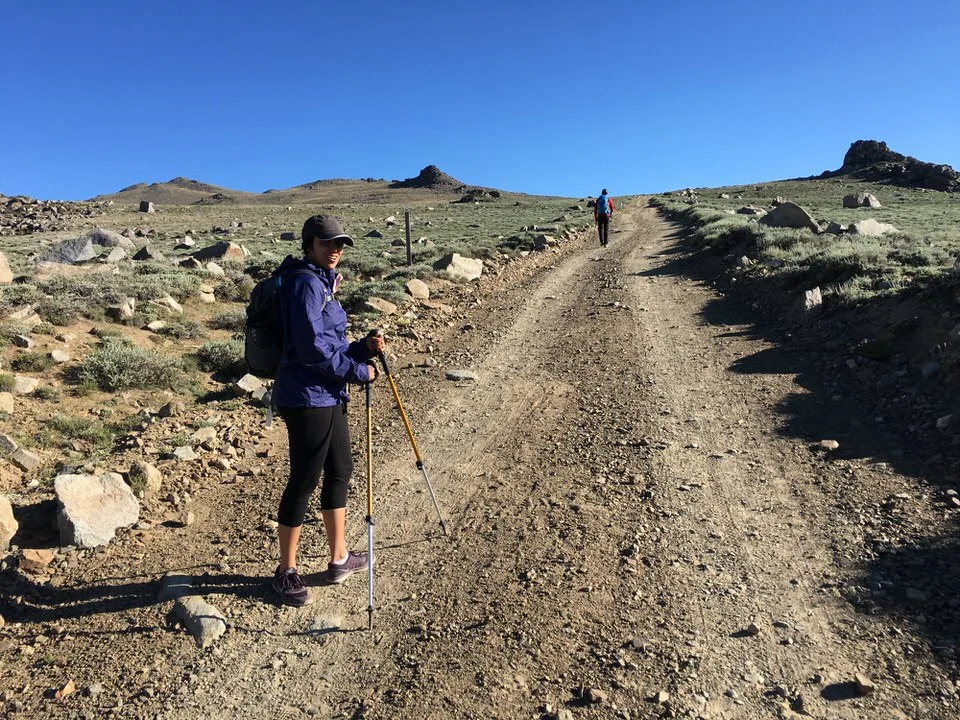
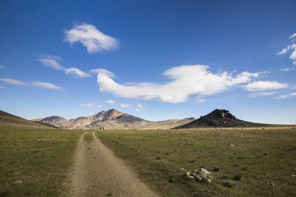
The trail is essentially a road most of the way, so it is pretty easy to follow
Even though the trail was straightforward, the terrain and landscape was still very beautiful! At some point you will pass a research station, but just keep on hiking.

Our hike went on mostly effortlessly except that I definitely could feel the altitude weighing down on me about halfway through the climb. So even though the terrain was easy, the altitude made the traveling fairly slow.

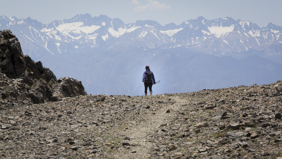
The giant Sierra Nevada Mountains looming in the background. We look like ants.

You can see the White Mountain Peak summit in the distance for a long time.
The last bit of the White Mountain trail is pretty steep and I was definitely very slow on this part because I was starting to get a pretty bad headache and nausea from the altitude. So I just took it a few steps at a time. Slowly but surely.

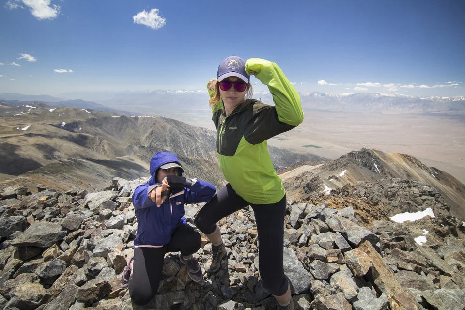
When we did finally make it to the top, we ate some lunch and enjoyed the summit views. You can see almost the whole stretch of the Sierra Nevada from up there, as well as the Owens River Valley. It was fun trying to name the peaks we knew from the other side.
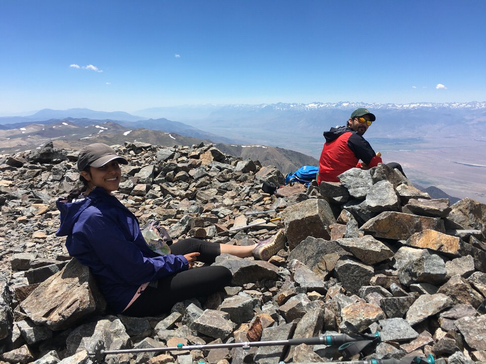
We signed the White Mountain Peak summit register, and took some summit pics.

Then we began the long trek down. I thought I would be pretty fast coming down, but the altitude really did me in for the rest of the hike, and it was slow going coming back.
All in all, the White Mountain Peak hike was great. It took us about 8 hours to complete, mostly because altitude sickness kept us from going any faster.
So definitely be prepared for altitude sickness since the hike starts at 12,000', but luckily, the trail is mellow enough that the altitude sickness seemed manageable.
Last but not least, we ended up getting a flat tire on our drive out from White Mountain trailhead about a mile into the 4WD road.
We used the fix-a-flat spray can we had in the car and were able to make it back (very, very slowly) all the way to Bakersfield, California.
Those fix-a-flat cans are only rated to about 100 miles, but it held up the whole way back. Regardless, I am now a believer in fix-a-flat cans and we take one with us every time we go on weekend trips (along with other car necessities). Don't head out on this trail without some backup!
And I hope you have a chance to go hike White Mountain Peak, it’s a worthy California bucket-list hike.
Let me know in the comments if you have had a chance to hike this peak or are planning your next adventure here!
MORE CALIFORNIA 14ER RESOURCES
Be sure to check out these guides to specific California 14ers and tips for training!
A Full List of All the California 14,000 Foot Peaks
Mount Whitney Trail – California 14er
Mount Langley Hike – California 14er
Split Mountain Hike – California 14er
Mount Shasta Hike – California 14er
Winter Ascent Mountaineers Route to Mount Whitney – California 14er
Tips to Hiking and Summitting Your First Fourteener Mountain
The Best Hikes in Southern California to Help Train for the Big Mountains
Cheers,
Allison - She Dreams of Alpine


Hiking Mt. Whitney Trail Guide: How to Successfully Summit the Highest Peak in the Lower 48 | This Mount Whitney Trail Guide is your A to Z resource on any and all things involving the Mount Whitney Hike. From day hiking Mt. Whitney to backpacking Mt Whitney, you’ll find everything you need to successfully summit and tackle one of the tallest peaks in the United States. A bucket list hike for every outdoor lover! | shedreamsofalpine.com